Sörforsa geodata
Sörforsa (Gävleborg) is a populated place; located in Sweden in Europe/Stockholm (GMT+2) time zone. With population of 1,581 people, there are 627 cities with bigger population in this country. Compared to other cities in Sweden, 84.7% of cities are located further ↓South; 73.4% of cities are located further ←West and 52.1% of cities have lower elevation than Sörforsa. Note1


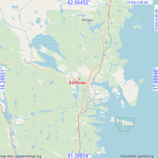
Sörforsa GPS coordinates[2]
61° 43' 59.988" North, 16° 58' 59.988" East
| Map corner | latitude | longitude |
|---|---|---|
| Upper-left | 62.06452°, | 16.28021° |
| Center: | 61.73333°, | 16.98333° |
| Lower-right: | 61.39854°, | 17.68646° |
| Map W x H: | 74.1×74 km | = 46×46mi |
| max Lat: | 67.85572° ⇑15.3% North |
| Sörforsa: | 61.73333° |
| min Lat: | ⇓84.7% South 55.34337° |
| min Long | Sörforsa | max Long |
| 11.1712° | 16.98333° | 24.13676° |
| W 73.4%⇐ | ⇒26.6% E |
Elevation
Elevation of Sörforsa is 54 m = 177 ft, and this is 28.6 m = 94 ft below average elevation for this country.
| Max E: |
663 m = 2175 ft | 47.9% |
| Avg. | 82.6 m = 271 ft | |
| Sörforsa | 54 m = 177 ft | |
Min E: |
-1 m = -3 ft | 52.1% |
See also: Sweden elevation on elevation.city.
Geographical zone
Sörforsa is located in North temperate zone (between Tropic of Cancer and the Arctic Circle). Distance of this North polar circle is 537.1 km =333.7 mi to North.| Distance of | km | miles | from Sörforsa |
|---|---|---|---|
| North Pole | 3143 | 1953 | to North |
| Arctic Circle | 537.1 | 333.7 | to North |
| Tropic Cancer | 4258.2 | 2645.9 | to South |
| Equator | 6864.1 | 4265.2 | to South |


Nearby cities:
15 places around Sörforsa: (largest is in red/bold)
• Arbrå
43.4 km =27 mi,  226°
226°
• Bergsjö
28 km =17.4 mi,  8°
8°
• Delsbo
23.7 km =14.7 mi,  288°
288°
• Enånger
20.9 km =13 mi,  176°
176°
• Friggesund
29.1 km =18.1 mi,  308°
308°
• Gnarp
37.9 km =23.5 mi,  22°
22°
• Harmånger
24.9 km =15.5 mi,  29°
29°
• Hudiksvall
6.5 km =4 mi,  95°
95°
• Iggesund
11.2 km =7 mi,  154°
154°
• Järvsö
43.1 km =26.8 mi,  267°
267°
• Ljusdal
48.1 km =29.9 mi,  282°
282°
• Mohed
49.2 km =30.6 mi,  190°
190°
• Njutånger
14 km =8.7 mi,  164°
164°
• Näsviken
7.2 km =4.5 mi,  301°
301°
• Söderhamn
47.9 km =29.8 mi, 175°
Sources, notices
• [Note1] Compared only with cities in Sweden existing in our database
• [Src1] Map data: © OpenStreetMap contributors (CC-BY-SA)
• [Src2] Other city data from geonames.org with taken over terms of usage.
• [Src3] Geographical zone / Annual Mean Temperature by Robert A. Rohde @ Wikipedia
