Friggesund geodata
Friggesund (Gävleborg) is a populated place; located in Sweden in Europe/Stockholm (GMT+2) time zone. With population of 530 people, there are 1273 cities with bigger population in this country. Compared to other cities in Sweden, 85.2% of cities are located further ↓South; 69% of cities are located further ←West and 50.2% of cities have higher elevation than Friggesund. Note1


Friggesund GPS coordinates[2]
61° 53' 45.78" North, 16° 32' 56.544" East
| Map corner | latitude | longitude |
|---|---|---|
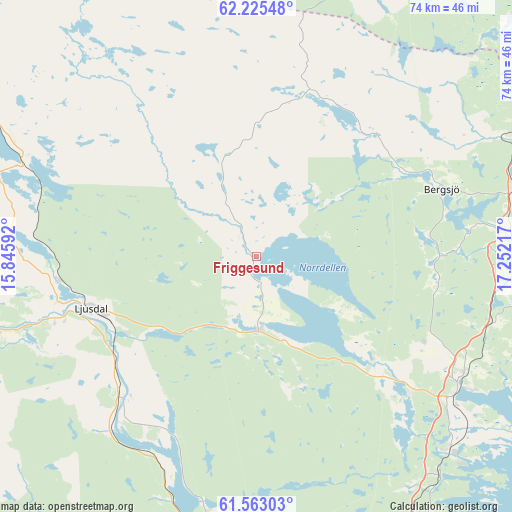
| Upper-left | 62.22548°, | 15.84592° |
| Center: | 61.89605°, | 16.54904° |
| Lower-right: | 61.56303°, | 17.25217° |
| Map W x H: | 73.7×73.7 km | = 45.8×45.8mi |
| max Lat: | 67.85572° ⇑14.8% North |
| Friggesund: | 61.89605° |
| min Lat: | ⇓85.2% South 55.34337° |
| min Long | Friggesund | max Long |
| 11.1712° | 16.54904° | 24.13676° |
| W 69%⇐ | ⇒31% E |
Elevation
Elevation of Friggesund is 50 m = 164 ft, and this is 32.6 m = 107 ft below average elevation for this country.
| Max E: |
663 m = 2175 ft | 50.2% |
| Avg. | 82.6 m = 271 ft | |
| Friggesund | 50 m = 164 ft | |
Min E: |
-1 m = -3 ft | 49.8% |
See also: Sweden elevation on elevation.city.
Geographical zone
Friggesund is located in North temperate zone (between Tropic of Cancer and the Arctic Circle). Distance of this North polar circle is 519 km =322.5 mi to North.| Distance of | km | miles | from Friggesund |
|---|---|---|---|
| North Pole | 3124.9 | 1941.7 | to North |
| Arctic Circle | 519 | 322.5 | to North |
| Tropic Cancer | 4276.3 | 2657.2 | to South |
| Equator | 6882.2 | 4276.4 | to South |


Nearby cities:
15 places around Friggesund: (largest is in red/bold)
• Arbrå
48.5 km =30.1 mi,  190°
190°
• Bergsjö
28.6 km =17.8 mi,  70°
70°
• Delsbo
10.6 km =6.6 mi,  178°
178°
• Enånger
45.9 km =28.5 mi,  148°
148°
• Färila
38.5 km =23.9 mi,  253°
253°
• Gnarp
40.8 km =25.4 mi, 65°
• Harmånger
35.2 km =21.9 mi,  84°
84°
• Hudiksvall
34.7 km =21.6 mi,  122°
122°
• Iggesund
39.5 km =24.5 mi,  135°
135°
• Järvsö
28.3 km =17.6 mi,  225°
225°
• Ljusdal
25.1 km =15.6 mi, 252°
• Njutånger
41.3 km =25.7 mi, 139°
• Näsviken
22 km =13.7 mi,  130°
130°
• Sörforsa
29.1 km =18.1 mi, 128°
• Tallåsen
28.1 km =17.5 mi,  263°
263°
Sources, notices
• [Note1] Compared only with cities in Sweden existing in our database
• [Src1] Map data: © OpenStreetMap contributors (CC-BY-SA)
• [Src2] Other city data from geonames.org with taken over terms of usage.
• [Src3] Geographical zone / Annual Mean Temperature by Robert A. Rohde @ Wikipedia
