Karlskoga geodata
Karlskoga (Örebro) is a seat of a second-order administrative division; located in Sweden in Europe/Stockholm (GMT+2) time zone. With population of 27,490 people, there are 56 cities with bigger population in this country. Compared to other cities in Sweden, 61.1% of cities are located further ↓South; 56.6% of cities are located further →East and 74.8% of cities have lower elevation than Karlskoga. Note1


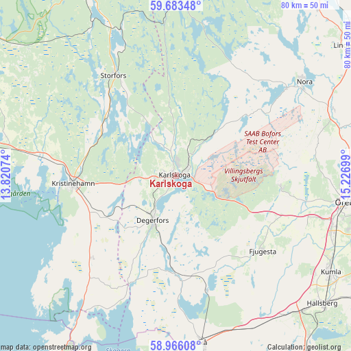
Karlskoga GPS coordinates[2]
59° 19' 36.012" North, 14° 31' 25.896" East
| Map corner | latitude | longitude |
|---|---|---|
| Upper-left | 59.68348°, | 13.82074° |
| Center: | 59.32667°, | 14.52386° |
| Lower-right: | 58.96608°, | 15.22699° |
| Map W x H: | 79.8×79.8 km | = 49.6×49.6mi |
| max Lat: | 67.85572° ⇑38.9% North |
| Karlskoga: | 59.32667° |
| min Lat: | ⇓61.1% South 55.34337° |
| min Long | Karlskoga | max Long |
| 11.1712° | 14.52386° | 24.13676° |
| W 43.4%⇐ | ⇒56.6% E |
Elevation
Elevation of Karlskoga is 119 m = 390 ft, and this is 36.4 m = 119 ft above average elevation for this country.
| Max E: |
663 m = 2175 ft | 25.2% |
| Karlskoga | 119 m 390 ft | |
| Avg. | 82.6 m = 271 ft | |
Min E: |
-1 m = -3 ft | 74.8% |
See also: Sweden elevation on elevation.city.
Geographical zone
Karlskoga is located in North temperate zone (between Tropic of Cancer and the Arctic Circle). Distance of this North polar circle is 804.7 km =500 mi to North.| Distance of | km | miles | from Karlskoga |
|---|---|---|---|
| North Pole | 3410.6 | 2119.2 | to North |
| Arctic Circle | 804.7 | 500 | to North |
| Tropic Cancer | 3990.6 | 2479.6 | to South |
| Equator | 6596.5 | 4098.9 | to South |


Nearby cities:
15 places around Karlskoga: (largest is in red/bold)
• Baggetorp
20.6 km =12.8 mi,  162°
162°
• Björneborg
18.3 km =11.4 mi,  238°
238°
• Degerfors
11.2 km =7 mi,  208°
208°
• Fjugesta
26.1 km =16.2 mi,  130°
130°
• Garphyttan
24.1 km =15 mi,  95°
95°
• Gyttorp
31.9 km =19.8 mi,  51°
51°
• Kristinehamn
23.7 km =14.7 mi,  265°
265°
• Latorpsbruk
26.8 km =16.7 mi, 102°
• Mullhyttan
21.6 km =13.4 mi, 155°
• Nora
36.2 km =22.5 mi, 53°
• Nykroppa
35.2 km =21.9 mi,  339°
339°
• Sjötorp
23.3 km =14.5 mi,  318°
318°
• Storfors
26.9 km =16.7 mi,  328°
328°
• Velanda
33.9 km =21.1 mi,  114°
114°
• Vintrosa
25.7 km =16 mi, 109°
Sources, notices
• [Note1] Compared only with cities in Sweden existing in our database
• [Src1] Map data: © OpenStreetMap contributors (CC-BY-SA)
• [Src2] Other city data from geonames.org with taken over terms of usage.
• [Src3] Geographical zone / Annual Mean Temperature by Robert A. Rohde @ Wikipedia
