Grythyttan geodata
Grythyttan (Örebro) is a populated place; located in Sweden in Europe/Stockholm (GMT+2) time zone. With population of 859 people, there are 919 cities with bigger population in this country. Compared to other cities in Sweden, 69.8% of cities are located further ↓South; 56.4% of cities are located further →East and 88.4% of cities have lower elevation than Grythyttan. Note1
Administrative division(s):
- Level 1: Örebro
- Level 2: Hällefors Kommun
- Level 3: Grythyttan
- Level 4: Grythyttan socken


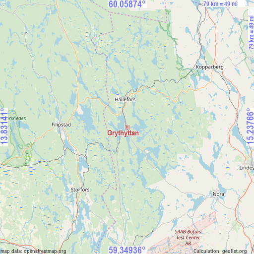
Grythyttan GPS coordinates[2]
59° 42' 21.348" North, 14° 32' 4.308" East
| Map corner | latitude | longitude |
|---|---|---|
| Upper-left | 60.05874°, | 13.83141° |
| Center: | 59.70593°, | 14.53453° |
| Lower-right: | 59.34936°, | 15.23766° |
| Map W x H: | 78.9×78.9 km | = 49×49mi |
| max Lat: | 67.85572° ⇑30.2% North |
| Grythyttan: | 59.70593° |
| min Lat: | ⇓69.8% South 55.34337° |
| min Long | Grythyttan | max Long |
| 11.1712° | 14.53453° | 24.13676° |
| W 43.6%⇐ | ⇒56.4% E |
Elevation
Elevation of Grythyttan is 187 m = 614 ft, and this is 104.4 m = 343 ft above average elevation for this country.
| Max E: |
663 m = 2175 ft | 11.6% |
| Grythyttan | 187 m 614 ft | |
| Avg. | 82.6 m = 271 ft | |
Min E: |
-1 m = -3 ft | 88.4% |
See also: Sweden elevation on elevation.city.
Geographical zone
Grythyttan is located in North temperate zone (between Tropic of Cancer and the Arctic Circle). Distance of this North polar circle is 762.5 km =473.8 mi to North.| Distance of | km | miles | from Grythyttan |
|---|---|---|---|
| North Pole | 3368.4 | 2093 | to North |
| Arctic Circle | 762.5 | 473.8 | to North |
| Tropic Cancer | 4032.8 | 2505.9 | to South |
| Equator | 6638.7 | 4125.1 | to South |


Nearby cities:
15 places around Grythyttan: (largest is in red/bold)
• Filipstad
20.6 km =12.8 mi,  271°
271°
• Fredriksberg
48.3 km =30 mi,  349°
349°
• Gyttorp
33 km =20.5 mi,  132°
132°
• Hällefors
8.7 km =5.4 mi,  355°
355°
• Karlskoga
42.2 km =26.2 mi,  180°
180°
• Kopparberg
31.9 km =19.8 mi,  53°
53°
• Lesjöfors
35.9 km =22.3 mi,  326°
326°
• Lindesberg
41.1 km =25.5 mi,  107°
107°
• Molkom
47.2 km =29.3 mi,  255°
255°
• Nora
35.2 km =21.9 mi, 126°
• Nykroppa
16 km =9.9 mi,  234°
234°
• Sjötorp
29.5 km =18.3 mi,  212°
212°
• Storfors
24.3 km =15.1 mi,  217°
217°
• Storå
33.5 km =20.8 mi,  88°
88°
• Vedevåg
47 km =29.2 mi,  115°
115°
Sources, notices
• [Note1] Compared only with cities in Sweden existing in our database
• [Src1] Map data: © OpenStreetMap contributors (CC-BY-SA)
• [Src2] Other city data from geonames.org with taken over terms of usage.
• [Src3] Geographical zone / Annual Mean Temperature by Robert A. Rohde @ Wikipedia
