Kristdala geodata
Kristdala (Kalmar) is a populated place; located in Sweden in Europe/Stockholm (GMT+2) time zone. With population of 1,016 people, there are 806 cities with bigger population in this country. Compared to other cities in Sweden, 73.1% of cities are located further ↑North; 64.1% of cities are located further ←West and 61.2% of cities have lower elevation than Kristdala. Note1


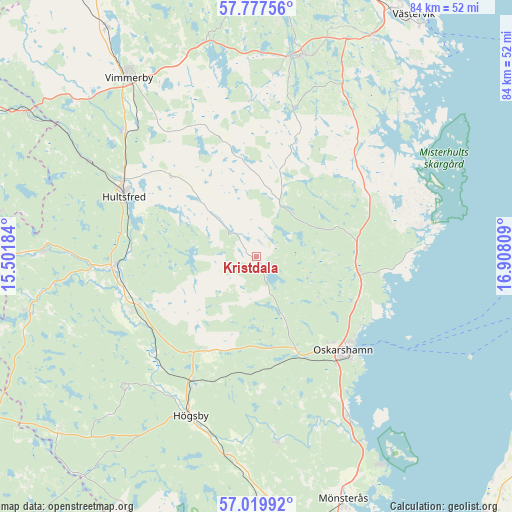
Kristdala GPS coordinates[2]
57° 24' 2.52" North, 16° 12' 17.856" East
| Map corner | latitude | longitude |
|---|---|---|
| Upper-left | 57.77756°, | 15.50184° |
| Center: | 57.4007°, | 16.20496° |
| Lower-right: | 57.01992°, | 16.90809° |
| Map W x H: | 84.2×84.2 km | = 52.3×52.3mi |
| max Lat: | 67.85572° ⇑73.1% North |
| Kristdala: | 57.4007° |
| min Lat: | ⇓26.9% South 55.34337° |
| min Long | Kristdala | max Long |
| 11.1712° | 16.20496° | 24.13676° |
| W 64.1%⇐ | ⇒35.9% E |
Elevation
Elevation of Kristdala is 73 m = 240 ft, and this is 9.6 m = 31 ft below average elevation for this country.
| Max E: |
663 m = 2175 ft | 38.8% |
| Avg. | 82.6 m = 271 ft | |
| Kristdala | 73 m = 240 ft | |
Min E: |
-1 m = -3 ft | 61.2% |
See also: Sweden elevation on elevation.city.
Geographical zone
Kristdala is located in North temperate zone (between Tropic of Cancer and the Arctic Circle). Distance of this North polar circle is 1018.8 km =633.1 mi to North.| Distance of | km | miles | from Kristdala |
|---|---|---|---|
| North Pole | 3624.7 | 2252.3 | to North |
| Arctic Circle | 1018.8 | 633.1 | to North |
| Tropic Cancer | 3776.4 | 2346.5 | to South |
| Equator | 6382.4 | 3965.8 | to South |


Nearby cities:
15 places around Kristdala: (largest is in red/bold)
• Ankarsrum
34 km =21.1 mi,  13°
13°
• Berga
22.9 km =14.2 mi,  206°
206°
• Figeholm
21 km =13 mi,  100°
100°
• Fliseryd
30 km =18.6 mi,  172°
172°
• Hultsfred
23.7 km =14.7 mi,  294°
294°
• Högsby
28.2 km =17.5 mi,  202°
202°
• Järnforsen
35.3 km =21.9 mi,  272°
272°
• Målilla
23.9 km =14.9 mi, 266°
• Mörlunda
23.2 km =14.4 mi,  246°
246°
• Oskarshamn
21 km =13 mi,  136°
136°
• Påskallavik
29.9 km =18.6 mi,  150°
150°
• Ruda
32.9 km =20.4 mi,  189°
189°
• Silverdalen
31.3 km =19.4 mi,  299°
299°
• Storebro
29.4 km =18.3 mi,  313°
313°
• Vimmerby
36.1 km =22.4 mi,  324°
324°
Sources, notices
• [Note1] Compared only with cities in Sweden existing in our database
• [Src1] Map data: © OpenStreetMap contributors (CC-BY-SA)
• [Src2] Other city data from geonames.org with taken over terms of usage.
• [Src3] Geographical zone / Annual Mean Temperature by Robert A. Rohde @ Wikipedia
