Svalöv geodata
Svalöv (Skåne) is a seat of a second-order administrative division; located in Sweden in Europe/Stockholm (GMT+2) time zone. With population of 3,852 people, there are 336 cities with bigger population in this country. Compared to other cities in Sweden, 93.8% of cities are located further ↑North; 77.3% of cities are located further →East and 54.9% of cities have lower elevation than Svalöv. Note1


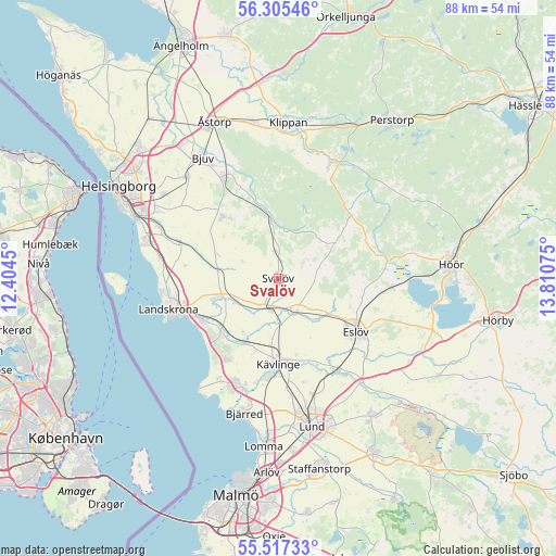
Svalöv GPS coordinates[2]
55° 54' 48.24" North, 13° 6' 27.432" East
| Map corner | latitude | longitude |
|---|---|---|
| Upper-left | 56.30546°, | 12.4045° |
| Center: | 55.9134°, | 13.10762° |
| Lower-right: | 55.51733°, | 13.81075° |
| Map W x H: | 87.6×87.6 km | = 54.4×54.4mi |
| max Lat: | 67.85572° ⇑93.8% North |
| Svalöv: | 55.9134° |
| min Lat: | ⇓6.2% South 55.34337° |
| min Long | Svalöv | max Long |
| 11.1712° | 13.10762° | 24.13676° |
| W 22.7%⇐ | ⇒77.3% E |
Elevation
Elevation of Svalöv is 59 m = 194 ft, and this is 23.6 m = 77 ft below average elevation for this country.
| Max E: |
663 m = 2175 ft | 45.1% |
| Avg. | 82.6 m = 271 ft | |
| Svalöv | 59 m = 194 ft | |
Min E: |
-1 m = -3 ft | 54.9% |
See also: Sweden elevation on elevation.city.
Geographical zone
Svalöv is located in North temperate zone (between Tropic of Cancer and the Arctic Circle). Distance of this North polar circle is 1184.2 km =735.8 mi to North.| Distance of | km | miles | from Svalöv |
|---|---|---|---|
| North Pole | 3790.1 | 2355.1 | to North |
| Arctic Circle | 1184.2 | 735.8 | to North |
| Tropic Cancer | 3611.1 | 2243.8 | to South |
| Equator | 6217 | 3863.1 | to South |


Nearby cities:
15 places around Svalöv: (largest is in red/bold)
• Asmundtorp
11.4 km =7.1 mi,  252°
252°
• Billeberga
7.5 km =4.7 mi,  243°
243°
• Dösjebro
11.4 km =7.1 mi,  205°
205°
• Ekeby
13 km =8.1 mi,  317°
317°
• Eslöv
14.8 km =9.2 mi,  123°
123°
• Furulund
15.6 km =9.7 mi,  184°
184°
• Hofterup
14.5 km =9 mi, 213°
• Häljarp
13.8 km =8.6 mi, 239°
• Kävlinge
13.5 km =8.4 mi, 179°
• Kågeröd
9.7 km =6 mi,  352°
352°
• Marieholm
5.8 km =3.6 mi,  153°
153°
• Röstånga
14.6 km =9.1 mi,  48°
48°
• Saxtorpsskogen
13.6 km =8.5 mi,  228°
228°
• Teckomatorp
5.4 km =3.4 mi,  196°
196°
• Vallåkra
16.5 km =10.3 mi,  288°
288°
Sources, notices
• [Note1] Compared only with cities in Sweden existing in our database
• [Src1] Map data: © OpenStreetMap contributors (CC-BY-SA)
• [Src2] Other city data from geonames.org with taken over terms of usage.
• [Src3] Geographical zone / Annual Mean Temperature by Robert A. Rohde @ Wikipedia
