Sätila geodata
Sätila (Västra Götaland) is a populated place; located in Sweden in Europe/Stockholm (GMT+2) time zone. With population of 1,210 people, there are 736 cities with bigger population in this country. Compared to other cities in Sweden, 71% of cities are located further ↑North; 89.1% of cities are located further →East and 52.1% of cities have lower elevation than Sätila. Note1


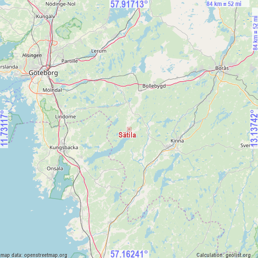
Sätila GPS coordinates[2]
57° 32' 30.192" North, 12° 26' 3.444" East
| Map corner | latitude | longitude |
|---|---|---|
| Upper-left | 57.91713°, | 11.73117° |
| Center: | 57.54172°, | 12.43429° |
| Lower-right: | 57.16241°, | 13.13742° |
| Map W x H: | 83.9×83.9 km | = 52.1×52.1mi |
| max Lat: | 67.85572° ⇑71% North |
| Sätila: | 57.54172° |
| min Lat: | ⇓29% South 55.34337° |
| min Long | Sätila | max Long |
| 11.1712° | 12.43429° | 24.13676° |
| W 10.9%⇐ | ⇒89.1% E |
Elevation
Elevation of Sätila is 54 m = 177 ft, and this is 28.6 m = 94 ft below average elevation for this country.
| Max E: |
663 m = 2175 ft | 47.9% |
| Avg. | 82.6 m = 271 ft | |
| Sätila | 54 m = 177 ft | |
Min E: |
-1 m = -3 ft | 52.1% |
See also: Sweden elevation on elevation.city.
Geographical zone
Sätila is located in North temperate zone (between Tropic of Cancer and the Arctic Circle). Distance of this North polar circle is 1003.1 km =623.3 mi to North.| Distance of | km | miles | from Sätila |
|---|---|---|---|
| North Pole | 3609 | 2242.5 | to North |
| Arctic Circle | 1003.1 | 623.3 | to North |
| Tropic Cancer | 3792.1 | 2356.3 | to South |
| Equator | 6398 | 3975.5 | to South |


Nearby cities:
15 places around Sätila: (largest is in red/bold)
• Björketorp
13.9 km =8.6 mi,  157°
157°
• Bollebygd
16.3 km =10.1 mi,  30°
30°
• Fjärås kyrkby
18 km =11.2 mi,  239°
239°
• Fritsla
21 km =13 mi,  85°
85°
• Hindås
18 km =11.2 mi,  2°
2°
• Horred
21 km =13 mi,  172°
172°
• Hyssna
6.4 km =4 mi,  74°
74°
• Härryda
13.2 km =8.2 mi,  341°
341°
• Kinna
16 km =9.9 mi,  103°
103°
• Kungsbacka
22.2 km =13.8 mi,  254°
254°
• Landvetter
20.9 km =13 mi,  320°
320°
• Lindome
21.1 km =13.1 mi,  277°
277°
• Mölnlycke
22.9 km =14.2 mi,  304°
304°
• Olsfors
22.9 km =14.2 mi,  43°
43°
• Rävlanda
13 km =8.1 mi,  16°
16°
Sources, notices
• [Note1] Compared only with cities in Sweden existing in our database
• [Src1] Map data: © OpenStreetMap contributors (CC-BY-SA)
• [Src2] Other city data from geonames.org with taken over terms of usage.
• [Src3] Geographical zone / Annual Mean Temperature by Robert A. Rohde @ Wikipedia
