Härryda geodata
Härryda (Västra Götaland) is a populated place; located in Sweden in Europe/Stockholm (GMT+2) time zone. With population of 861 people, there are 917 cities with bigger population in this country. Compared to other cities in Sweden, 69.2% of cities are located further ↑North; 89.6% of cities are located further →East and 78.5% of cities have lower elevation than Härryda. Note1


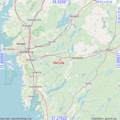
Härryda GPS coordinates[2]
57° 39' 15.696" North, 12° 21' 47.448" East
| Map corner | latitude | longitude |
|---|---|---|
| Upper-left | 58.0286°, | 11.66006° |
| Center: | 57.65436°, | 12.36318° |
| Lower-right: | 57.27622°, | 13.06631° |
| Map W x H: | 83.7×83.7 km | = 52×52mi |
| max Lat: | 67.85572° ⇑69.2% North |
| Härryda: | 57.65436° |
| min Lat: | ⇓30.8% South 55.34337° |
| min Long | Härryda | max Long |
| 11.1712° | 12.36318° | 24.13676° |
| W 10.4%⇐ | ⇒89.6% E |
Elevation
Elevation of Härryda is 137 m = 449 ft, and this is 54.4 m = 178 ft above average elevation for this country.
| Max E: |
663 m = 2175 ft | 21.5% |
| Härryda | 137 m 449 ft | |
| Avg. | 82.6 m = 271 ft | |
Min E: |
-1 m = -3 ft | 78.5% |
See also: Sweden elevation on elevation.city.
Geographical zone
Härryda is located in North temperate zone (between Tropic of Cancer and the Arctic Circle). Distance of this North polar circle is 990.6 km =615.5 mi to North.| Distance of | km | miles | from Härryda |
|---|---|---|---|
| North Pole | 3596.5 | 2234.8 | to North |
| Arctic Circle | 990.6 | 615.5 | to North |
| Tropic Cancer | 3804.6 | 2364.1 | to South |
| Equator | 6410.6 | 3983.4 | to South |


Nearby cities:
15 places around Härryda: (largest is in red/bold)
• Bollebygd
12.6 km =7.8 mi,  82°
82°
• Furulund
15.3 km =9.5 mi,  296°
296°
• Hindås
7.4 km =4.6 mi,  42°
42°
• Hyssna
15 km =9.3 mi,  135°
135°
• Jonsered
15.2 km =9.4 mi,  312°
312°
• Kåhög
16.5 km =10.3 mi, 310°
• Landvetter
9.7 km =6 mi,  291°
291°
• Lerum
14.1 km =8.8 mi,  336°
336°
• Mölnlycke
14.6 km =9.1 mi,  271°
271°
• Partille
18 km =11.2 mi, 301°
• Rävlanda
8 km =5 mi,  90°
90°
• Stenkullen
15.9 km =9.9 mi,  350°
350°
• Sätila
13.2 km =8.2 mi,  161°
161°
• Öjersjö
14.5 km =9 mi, 289°
• Öxeryd
10.4 km =6.5 mi,  331°
331°
Sources, notices
• [Note1] Compared only with cities in Sweden existing in our database
• [Src1] Map data: © OpenStreetMap contributors (CC-BY-SA)
• [Src2] Other city data from geonames.org with taken over terms of usage.
• [Src3] Geographical zone / Annual Mean Temperature by Robert A. Rohde @ Wikipedia
