Stjärnhov geodata
Stjärnhov (Södermanland) is a populated place; located in Sweden in Europe/Stockholm (GMT+2) time zone. With population of 555 people, there are 1226 cities with bigger population in this country. Compared to other cities in Sweden, 54.9% of cities are located further ↓South; 73.5% of cities are located further ←West and 56.2% of cities have lower elevation than Stjärnhov. Note1


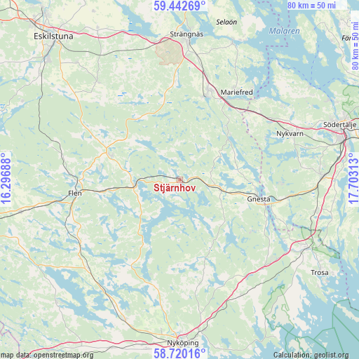
Stjärnhov GPS coordinates[2]
59° 4' 59.988" North, 17° 0' 0" East
| Map corner | latitude | longitude |
|---|---|---|
| Upper-left | 59.44269°, | 16.29688° |
| Center: | 59.08333°, | 17° |
| Lower-right: | 58.72016°, | 17.70313° |
| Map W x H: | 80.3×80.3 km | = 49.9×49.9mi |
| max Lat: | 67.85572° ⇑45.1% North |
| Stjärnhov: | 59.08333° |
| min Lat: | ⇓54.9% South 55.34337° |
| min Long | Stjärnhov | max Long |
| 11.1712° | 17° | 24.13676° |
| W 73.5%⇐ | ⇒26.5% E |
Elevation
Elevation of Stjärnhov is 62 m = 203 ft, and this is 20.6 m = 68 ft below average elevation for this country.
| Max E: |
663 m = 2175 ft | 43.8% |
| Avg. | 82.6 m = 271 ft | |
| Stjärnhov | 62 m = 203 ft | |
Min E: |
-1 m = -3 ft | 56.2% |
See also: Sweden elevation on elevation.city.
Geographical zone
Stjärnhov is located in North temperate zone (between Tropic of Cancer and the Arctic Circle). Distance of this North polar circle is 831.7 km =516.8 mi to North.| Distance of | km | miles | from Stjärnhov |
|---|---|---|---|
| North Pole | 3437.6 | 2136 | to North |
| Arctic Circle | 831.7 | 516.8 | to North |
| Tropic Cancer | 3963.5 | 2462.8 | to South |
| Equator | 6569.5 | 4082.1 | to South |


Nearby cities:
15 places around Stjärnhov: (largest is in red/bold)
• Björnlunda
9.3 km =5.8 mi,  102°
102°
• Flen
23.7 km =14.7 mi,  263°
263°
• Gnesta
18.3 km =11.4 mi, 102°
• Hälleforsnäs
29.7 km =18.5 mi,  284°
284°
• Malmköping
16.2 km =10.1 mi,  290°
290°
• Mariefred
23.4 km =14.5 mi,  32°
32°
• Marielund
21.3 km =13.2 mi, 29°
• Mellösa
25.8 km =16 mi,  274°
274°
• Mölnbo
24.1 km =15 mi, 98°
• Nykvarn
26.8 km =16.7 mi,  67°
67°
• Sparreholm
10.6 km =6.6 mi, 259°
• Tystberga
29.2 km =18.1 mi,  152°
152°
• Vrena
30.1 km =18.7 mi,  214°
214°
• Ärla
28.5 km =17.7 mi,  320°
320°
• Åkers Styckebruk
19.1 km =11.9 mi,  14°
14°
Sources, notices
• [Note1] Compared only with cities in Sweden existing in our database
• [Src1] Map data: © OpenStreetMap contributors (CC-BY-SA)
• [Src2] Other city data from geonames.org with taken over terms of usage.
• [Src3] Geographical zone / Annual Mean Temperature by Robert A. Rohde @ Wikipedia
