Malmköping geodata
Malmköping (Södermanland) is a populated place; located in Sweden in Europe/Stockholm (GMT+2) time zone. With population of 2,106 people, there are 506 cities with bigger population in this country. Compared to other cities in Sweden, 55.6% of cities are located further ↓South; 71.6% of cities are located further ←West and 54.9% of cities have lower elevation than Malmköping. Note1


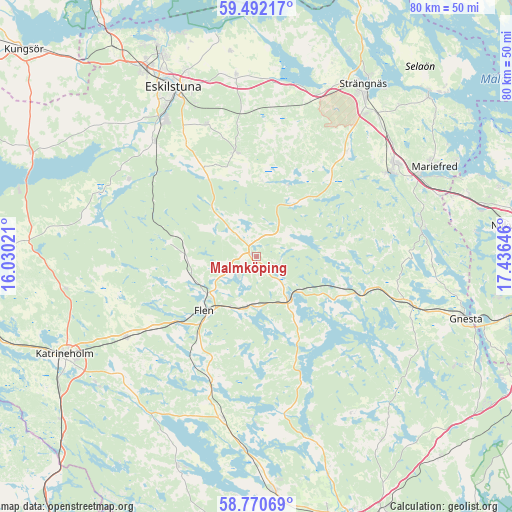
Malmköping GPS coordinates[2]
59° 7' 59.988" North, 16° 43' 59.988" East
| Map corner | latitude | longitude |
|---|---|---|
| Upper-left | 59.49217°, | 16.03021° |
| Center: | 59.13333°, | 16.73333° |
| Lower-right: | 58.77069°, | 17.43646° |
| Map W x H: | 80.2×80.2 km | = 49.8×49.8mi |
| max Lat: | 67.85572° ⇑44.4% North |
| Malmköping: | 59.13333° |
| min Lat: | ⇓55.6% South 55.34337° |
| min Long | Malmköping | max Long |
| 11.1712° | 16.73333° | 24.13676° |
| W 71.6%⇐ | ⇒28.4% E |
Elevation
Elevation of Malmköping is 59 m = 194 ft, and this is 23.6 m = 77 ft below average elevation for this country.
| Max E: |
663 m = 2175 ft | 45.1% |
| Avg. | 82.6 m = 271 ft | |
| Malmköping | 59 m = 194 ft | |
Min E: |
-1 m = -3 ft | 54.9% |
See also: Sweden elevation on elevation.city.
Geographical zone
Malmköping is located in North temperate zone (between Tropic of Cancer and the Arctic Circle). Distance of this North polar circle is 826.2 km =513.4 mi to North.| Distance of | km | miles | from Malmköping |
|---|---|---|---|
| North Pole | 3432.1 | 2132.6 | to North |
| Arctic Circle | 826.2 | 513.4 | to North |
| Tropic Cancer | 3969.1 | 2466.3 | to South |
| Equator | 6575 | 4085.5 | to South |


Nearby cities:
15 places around Malmköping: (largest is in red/bold)
• Björnlunda
25.5 km =15.8 mi,  107°
107°
• Flen
11.8 km =7.3 mi,  224°
224°
• Hällberga
21.8 km =13.5 mi,  339°
339°
• Hälleforsnäs
13.6 km =8.5 mi,  278°
278°
• Härad
27.1 km =16.8 mi,  20°
20°
• Hållsta
24 km =14.9 mi,  318°
318°
• Kjulaås
28 km =17.4 mi,  352°
352°
• Mellösa
11.1 km =6.9 mi,  250°
250°
• Skogstorp
25.6 km =15.9 mi,  326°
326°
• Sköldinge
19.9 km =12.4 mi,  235°
235°
• Sparreholm
8.8 km =5.5 mi,  147°
147°
• Stjärnhov
16.2 km =10.1 mi, 110°
• Valla
23.8 km =14.8 mi, 237°
• Ärla
16.6 km =10.3 mi, 349°
• Åkers Styckebruk
23.8 km =14.8 mi,  56°
56°
Sources, notices
• [Note1] Compared only with cities in Sweden existing in our database
• [Src1] Map data: © OpenStreetMap contributors (CC-BY-SA)
• [Src2] Other city data from geonames.org with taken over terms of usage.
• [Src3] Geographical zone / Annual Mean Temperature by Robert A. Rohde @ Wikipedia
