Sparreholm geodata
Sparreholm (Södermanland) is a populated place; located in Sweden in Europe/Stockholm (GMT+2) time zone. With population of 734 people, there are 1027 cities with bigger population in this country. Compared to other cities in Sweden, 54.9% of cities are located further ↓South; 72.1% of cities are located further ←West and 62.2% of cities have higher elevation than Sparreholm. Note1


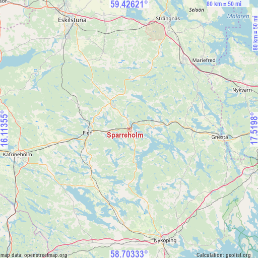
Sparreholm GPS coordinates[2]
59° 4' 0.012" North, 16° 49' 0.012" East
| Map corner | latitude | longitude |
|---|---|---|
| Upper-left | 59.42621°, | 16.11355° |
| Center: | 59.06667°, | 16.81667° |
| Lower-right: | 58.70333°, | 17.5198° |
| Map W x H: | 80.4×80.4 km | = 50×50mi |
| max Lat: | 67.85572° ⇑45.1% North |
| Sparreholm: | 59.06667° |
| min Lat: | ⇓54.9% South 55.34337° |
| min Long | Sparreholm | max Long |
| 11.1712° | 16.81667° | 24.13676° |
| W 72.1%⇐ | ⇒27.9% E |
Elevation
Elevation of Sparreholm is 33 m = 108 ft, and this is 49.6 m = 163 ft below average elevation for this country.
| Max E: |
663 m = 2175 ft | 62.2% |
| Avg. | 82.6 m = 271 ft | |
| Sparreholm | 33 m = 108 ft | |
Min E: |
-1 m = -3 ft | 37.8% |
See also: Sweden elevation on elevation.city.
Geographical zone
Sparreholm is located in North temperate zone (between Tropic of Cancer and the Arctic Circle). Distance of this North polar circle is 833.6 km =518 mi to North.| Distance of | km | miles | from Sparreholm |
|---|---|---|---|
| North Pole | 3439.5 | 2137.2 | to North |
| Arctic Circle | 833.6 | 518 | to North |
| Tropic Cancer | 3961.7 | 2461.7 | to South |
| Equator | 6567.6 | 4080.9 | to South |


Nearby cities:
15 places around Sparreholm: (largest is in red/bold)
• Björnlunda
19.6 km =12.2 mi,  90°
90°
• Flen
13.1 km =8.1 mi,  265°
265°
• Gnesta
28.4 km =17.6 mi, 94°
• Hälleforsnäs
20.6 km =12.8 mi,  297°
297°
• Malmköping
8.8 km =5.5 mi,  327°
327°
• Marielund
29.2 km =18.1 mi,  45°
45°
• Mellösa
15.7 km =9.8 mi,  283°
283°
• Olstorp
29.7 km =18.5 mi,  200°
200°
• Sköldinge
21.5 km =13.4 mi,  259°
259°
• Stigtomta
29.7 km =18.5 mi,  183°
183°
• Stjärnhov
10.6 km =6.6 mi,  79°
79°
• Valla
25.4 km =15.8 mi, 257°
• Vrena
23.8 km =14.8 mi, 196°
• Ärla
25 km =15.5 mi,  341°
341°
• Åkers Styckebruk
25.4 km =15.8 mi,  36°
36°
Sources, notices
• [Note1] Compared only with cities in Sweden existing in our database
• [Src1] Map data: © OpenStreetMap contributors (CC-BY-SA)
• [Src2] Other city data from geonames.org with taken over terms of usage.
• [Src3] Geographical zone / Annual Mean Temperature by Robert A. Rohde @ Wikipedia
