Hällefors geodata
Hällefors (Örebro) is a seat of a second-order administrative division; located in Sweden in Europe/Stockholm (GMT+2) time zone. With population of 4,449 people, there are 304 cities with bigger population in this country. Compared to other cities in Sweden, 71% of cities are located further ↓South; 56.7% of cities are located further →East and 90% of cities have lower elevation than Hällefors. Note1


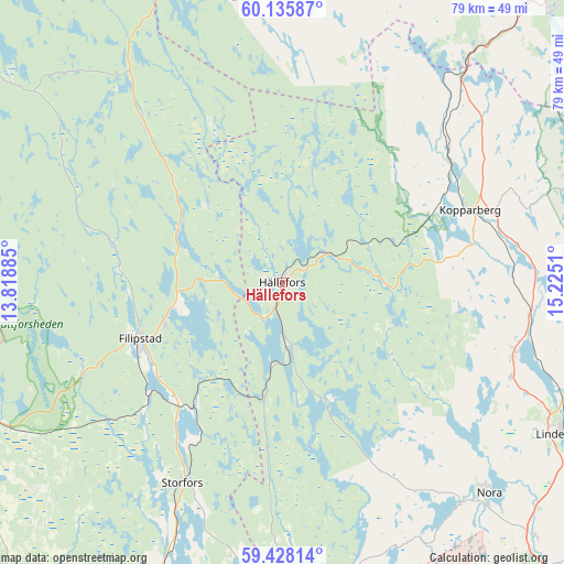
Hällefors GPS coordinates[2]
59° 47' 1.968" North, 14° 31' 19.092" East
| Map corner | latitude | longitude |
|---|---|---|
| Upper-left | 60.13587°, | 13.81885° |
| Center: | 59.78388°, | 14.52197° |
| Lower-right: | 59.42814°, | 15.2251° |
| Map W x H: | 78.7×78.7 km | = 48.9×48.9mi |
| max Lat: | 67.85572° ⇑29% North |
| Hällefors: | 59.78388° |
| min Lat: | ⇓71% South 55.34337° |
| min Long | Hällefors | max Long |
| 11.1712° | 14.52197° | 24.13676° |
| W 43.3%⇐ | ⇒56.7% E |
Elevation
Elevation of Hällefors is 201 m = 659 ft, and this is 118.4 m = 388 ft above average elevation for this country.
| Max E: |
663 m = 2175 ft | 10% |
| Hällefors | 201 m 659 ft | |
| Avg. | 82.6 m = 271 ft | |
Min E: |
-1 m = -3 ft | 90% |
See also: Sweden elevation on elevation.city.
Geographical zone
Hällefors is located in North temperate zone (between Tropic of Cancer and the Arctic Circle). Distance of this North polar circle is 753.8 km =468.4 mi to North.| Distance of | km | miles | from Hällefors |
|---|---|---|---|
| North Pole | 3359.7 | 2087.6 | to North |
| Arctic Circle | 753.8 | 468.4 | to North |
| Tropic Cancer | 4041.4 | 2511.2 | to South |
| Equator | 6647.3 | 4130.4 | to South |


Nearby cities:
15 places around Hällefors: (largest is in red/bold)
• Abborrberget
43.5 km =27 mi,  20°
20°
• Filipstad
21.3 km =13.2 mi,  248°
248°
• Fredriksberg
39.6 km =24.6 mi,  348°
348°
• Grythyttan
8.7 km =5.4 mi,  175°
175°
• Grängesberg
42.2 km =26.2 mi,  39°
39°
• Gyttorp
39.8 km =24.7 mi,  141°
141°
• Kopparberg
28.3 km =17.6 mi,  68°
68°
• Lesjöfors
28.5 km =17.7 mi,  318°
318°
• Lindesberg
45.1 km =28 mi,  118°
118°
• Nora
41.4 km =25.7 mi, 135°
• Nykroppa
21.7 km =13.5 mi,  214°
214°
• Saxdalen
47.9 km =29.8 mi,  32°
32°
• Sjötorp
36.7 km =22.8 mi,  204°
204°
• Storfors
31.3 km =19.4 mi, 206°
• Storå
35 km =21.7 mi,  102°
102°
Sources, notices
• [Note1] Compared only with cities in Sweden existing in our database
• [Src1] Map data: © OpenStreetMap contributors (CC-BY-SA)
• [Src2] Other city data from geonames.org with taken over terms of usage.
• [Src3] Geographical zone / Annual Mean Temperature by Robert A. Rohde @ Wikipedia
