Marielund geodata
Marielund (Norrbotten) is a populated place; located in Sweden in Europe/Stockholm (GMT+2) time zone. With population of 1,726 people, there are 588 cities with bigger population in this country. Compared to other cities in Sweden, 98.6% of cities are located further ↓South; 99.9% of cities are located further ←West and 87.5% of cities have higher elevation than Marielund. Note1
Administrative division(s):
- Level 1: Norrbotten
- Level 2: Haparanda Kommun
- Level 3: Nedertorneå-Haparanda
- Level 4: Nedertorneå socken


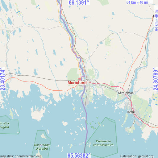
Marielund GPS coordinates[2]
65° 51' 11.052" North, 24° 6' 17.496" East
| Map corner | latitude | longitude |
|---|---|---|
| Upper-left | 66.1391°, | 23.40174° |
| Center: | 65.85307°, | 24.10486° |
| Lower-right: | 65.56382°, | 24.80799° |
| Map W x H: | 64×64 km | = 39.8×39.8mi |
| max Lat: | 67.85572° ⇑1.4% North |
| Marielund: | 65.85307° |
| min Lat: | ⇓98.6% South 55.34337° |
| min Long | Marielund | max Long |
| 11.1712° | 24.10486° | 24.13676° |
| W 99.9%⇐ | ⇒0.099999999999994% E |
Elevation
Elevation of Marielund is 11 m = 36 ft, and this is 71.6 m = 235 ft below average elevation for this country.
| Max E: |
663 m = 2175 ft | 87.5% |
| Avg. | 82.6 m = 271 ft | |
| Marielund | 11 m = 36 ft | |
Min E: |
-1 m = -3 ft | 12.5% |
See also: Sweden elevation on elevation.city.
Geographical zone
Marielund is located in North temperate zone (between Tropic of Cancer and the Arctic Circle). Distance of this North polar circle is 79 km =49.1 mi to North.| Distance of | km | miles | from Marielund |
|---|---|---|---|
| North Pole | 2684.9 | 1668.3 | to North |
| Arctic Circle | 79 | 49.1 | to North |
| Tropic Cancer | 4716.3 | 2930.6 | to South |
| Equator | 7322.2 | 4549.8 | to South |


Nearby cities:
15 places around Marielund: (largest is in red/bold)
• Bensbyn
88.2 km =54.8 mi,  254°
254°
• Björkskatan
92 km =57.2 mi, 253°
• Haparanda
2.4 km =1.5 mi,  143°
143°
• Kalix
43.1 km =26.8 mi,  269°
269°
• Luleå
94 km =58.4 mi, 251°
• Långvik
89.6 km =55.7 mi,  289°
289°
• Nyborg
41.9 km =26 mi,  259°
259°
• Risögrund
39.4 km =24.5 mi, 263°
• Rolfs
45 km =28 mi, 269°
• Rutvik
94.2 km =58.5 mi, 257°
• Råneå
82.5 km =51.3 mi, 270°
• Sangis
27.7 km =17.2 mi, 270°
• Töre
66.4 km =41.3 mi,  275°
275°
• Överkalix
77.5 km =48.2 mi,  312°
312°
• Övertorneå
62.8 km =39 mi,  341°
341°
Sources, notices
• [Note1] Compared only with cities in Sweden existing in our database
• [Src1] Map data: © OpenStreetMap contributors (CC-BY-SA)
• [Src2] Other city data from geonames.org with taken over terms of usage.
• [Src3] Geographical zone / Annual Mean Temperature by Robert A. Rohde @ Wikipedia
