Rovte geodata
Rovte (Logatec) is a populated place; located in Slovenia in Europe/Ljubljana (GMT+2) time zone. With population of 915 people, there are 242 cities with bigger population in this country. Compared to other cities in Slovenia, 74.3% of cities are located further ↑North; 81.8% of cities are located further →East and 96.8% of cities have lower elevation than Rovte. Note1


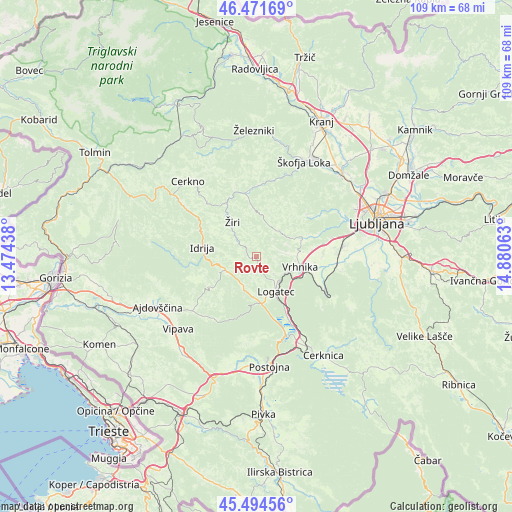
Rovte GPS coordinates[2]
45° 59' 7.008" North, 14° 10' 39" East
| Map corner | latitude | longitude |
|---|---|---|
| Upper-left | 46.47169°, | 13.47438° |
| Center: | 45.98528°, | 14.1775° |
| Lower-right: | 45.49456°, | 14.88063° |
| Map W x H: | 108.6×108.6 km | = 67.5×67.5mi |
| max Lat: | 46.83694° ⇑74.3% North |
| Rovte: | 45.98528° |
| min Lat: | ⇓25.7% South 45.47667° |
| min Long | Rovte | max Long |
| 13.52639° | 14.1775° | 16.4975° |
| W 18.2%⇐ | ⇒81.8% E |
Elevation
Elevation of Rovte is 694 m = 2277 ft, and this is 368.4 m = 1209 ft above average elevation for this country.
| Max E: |
1551 m = 5089 ft | 3.2% |
| Rovte | 694 m 2277 ft | |
| Avg. | 325.6 m = 1068 ft | |
Min E: |
2 m = 7 ft | 96.8% |
See also: Slovenia elevation on elevation.city.
Geographical zone
Rovte is located in North temperate zone (between Tropic of Cancer and the Arctic Circle). Distance of this North polar circle is 2288.1 km =1421.8 mi to North.| Distance of | km | miles | from Rovte |
|---|---|---|---|
| North Pole | 4894 | 3041 | to North |
| Arctic Circle | 2288.1 | 1421.8 | to North |
| Tropic Cancer | 2507.2 | 1557.9 | to South |
| Equator | 5113.1 | 3177.1 | to South |


Nearby cities:
15 places around Rovte: (largest is in red/bold)
• Drenov Grič
12.1 km =7.5 mi,  83°
83°
• Godovič
7.2 km =4.5 mi,  244°
244°
• Horjul
10.3 km =6.4 mi,  65°
65°
• Hotedršica
6.7 km =4.2 mi,  204°
204°
• Idrija
11.5 km =7.1 mi,  279°
279°
• Kalce
10.1 km =6.3 mi,  172°
172°
• Logatec
8.7 km =5.4 mi,  154°
154°
• Sinja Gorica
10.9 km =6.8 mi,  95°
95°
• Spodnja Idrija
12.7 km =7.9 mi,  294°
294°
• Stara Vrhnika
8.1 km =5 mi, 98°
• Verd
10.4 km =6.5 mi,  107°
107°
• Vrhnika
9.4 km =5.8 mi, 104°
• Vrzdenec
8.2 km =5.1 mi,  61°
61°
• Črni Vrh
12.4 km =7.7 mi, 236°
• Žiri
8.3 km =5.2 mi,  319°
319°
Sources, notices
• [Note1] Compared only with cities in Slovenia existing in our database
• [Src1] Map data: © OpenStreetMap contributors (CC-BY-SA)
• [Src2] Other city data from geonames.org with taken over terms of usage.
• [Src3] Geographical zone / Annual Mean Temperature by Robert A. Rohde @ Wikipedia
