Velenje geodata
Velenje is a seat of a first-order administrative division; located in Slovenia in Europe/Ljubljana (GMT+2) time zone. With population of 25,456 people, there are 4 cities with bigger population in this country. Compared to other cities in Slovenia, 61.2% of cities are located further ↓South; 56% of cities are located further ←West and 74% of cities have lower elevation than Velenje. Note1


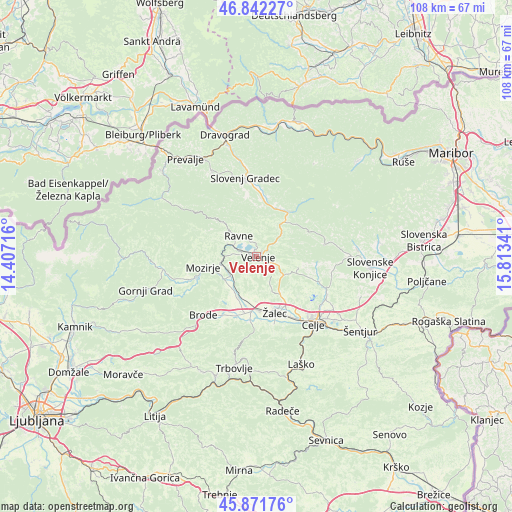
Velenje GPS coordinates[2]
46° 21' 33.012" North, 15° 6' 37.008" East
| Map corner | latitude | longitude |
|---|---|---|
| Upper-left | 46.84227°, | 14.40716° |
| Center: | 46.35917°, | 15.11028° |
| Lower-right: | 45.87176°, | 15.81341° |
| Map W x H: | 107.9×107.9 km | = 67×67mi |
| max Lat: | 46.83694° ⇑38.8% North |
| Velenje: | 46.35917° |
| min Lat: | ⇓61.2% South 45.47667° |
| min Long | Velenje | max Long |
| 13.52639° | 15.11028° | 16.4975° |
| W 56%⇐ | ⇒44% E |
Elevation
Elevation of Velenje is 391 m = 1283 ft, and this is 65.4 m = 215 ft above average elevation for this country.
| Max E: |
1551 m = 5089 ft | 26% |
| Velenje | 391 m 1283 ft | |
| Avg. | 325.6 m = 1068 ft | |
Min E: |
2 m = 7 ft | 74% |
See also: Slovenia elevation on elevation.city.
Geographical zone
Velenje is located in North temperate zone (between Tropic of Cancer and the Arctic Circle). Distance of this North polar circle is 2246.5 km =1395.9 mi to North.| Distance of | km | miles | from Velenje |
|---|---|---|---|
| North Pole | 4852.4 | 3015.1 | to North |
| Arctic Circle | 2246.5 | 1395.9 | to North |
| Tropic Cancer | 2548.7 | 1583.7 | to South |
| Equator | 5154.7 | 3203 | to South |


Nearby cities:
15 places around Velenje: (largest is in red/bold)
• Andraž nad Polzelo
4 km =2.5 mi,  199°
199°
• Dobrna
9.2 km =5.7 mi,  105°
105°
• Florjan
8.6 km =5.3 mi,  295°
295°
• Gaberke
4.9 km =3 mi,  330°
330°
• Gornji Dolič
9.1 km =5.7 mi,  38°
38°
• Letuš
8.1 km =5 mi,  233°
233°
• Lokovica
4.5 km =2.8 mi,  270°
270°
• Podkraj pri Velenju
1.8 km =1.1 mi,  245°
245°
• Polzela
9.1 km =5.7 mi, 201°
• Ravne
7.2 km =4.5 mi, 328°
• Studence
6.9 km =4.3 mi,  144°
144°
• Topolšica
8.2 km =5.1 mi, 303°
• Škale
1.9 km =1.2 mi,  346°
346°
• Šmartno ob Paki
6.6 km =4.1 mi,  244°
244°
• Šoštanj
5.3 km =3.3 mi, 296°
Sources, notices
• [Note1] Compared only with cities in Slovenia existing in our database
• [Src1] Map data: © OpenStreetMap contributors (CC-BY-SA)
• [Src2] Other city data from geonames.org with taken over terms of usage.
• [Src3] Geographical zone / Annual Mean Temperature by Robert A. Rohde @ Wikipedia
