Šmartno ob Paki geodata
Šmartno ob Paki is a seat of a first-order administrative division; located in Slovenia in Europe/Ljubljana (GMT+2) time zone. With population of 642 people, there are 399 cities with bigger population in this country. Compared to other cities in Slovenia, 57.7% of cities are located further ↓South; 51% of cities are located further ←West and 58.5% of cities have lower elevation than Šmartno ob Paki. Note1


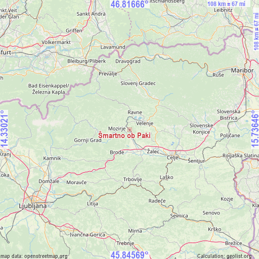
Šmartno ob Paki GPS coordinates[2]
46° 19' 59.988" North, 15° 1' 59.988" East
| Map corner | latitude | longitude |
|---|---|---|
| Upper-left | 46.81666°, | 14.33021° |
| Center: | 46.33333°, | 15.03333° |
| Lower-right: | 45.84569°, | 15.73646° |
| Map W x H: | 108×108 km | = 67.1×67.1mi |
| max Lat: | 46.83694° ⇑42.3% North |
| Šmartno ob Paki: | 46.33333° |
| min Lat: | ⇓57.7% South 45.47667° |
| min Long | Šmartno ob Pak | max Long |
| 13.52639° | 15.03333° | 16.4975° |
| W 51%⇐ | ⇒49% E |
Elevation
Elevation of Šmartno ob Paki is 322 m = 1056 ft, and this is 3.6 m = 12 ft below average elevation for this country.
| Max E: |
1551 m = 5089 ft | 41.5% |
| Avg. | 325.6 m = 1068 ft | |
| Šmartno ob Paki | 322 m = 1056 ft | |
Min E: |
2 m = 7 ft | 58.5% |
See also: Slovenia elevation on elevation.city.
Geographical zone
Šmartno ob Paki is located in North temperate zone (between Tropic of Cancer and the Arctic Circle). Distance of this North polar circle is 2249.4 km =1397.7 mi to North.| Distance of | km | miles | from Šmartno ob Paki |
|---|---|---|---|
| North Pole | 4855.3 | 3016.9 | to North |
| Arctic Circle | 2249.4 | 1397.7 | to North |
| Tropic Cancer | 2545.9 | 1581.9 | to South |
| Equator | 5151.8 | 3201.2 | to South |


Nearby cities:
15 places around Šmartno ob Paki: (largest is in red/bold)
• Andraž nad Polzelo
4.6 km =2.9 mi,  101°
101°
• Braslovče
4.9 km =3 mi,  174°
174°
• Florjan
6.9 km =4.3 mi,  344°
344°
• Gaberke
7.9 km =4.9 mi,  26°
26°
• Letuš
2 km =1.2 mi,  198°
198°
• Lokovica
3.2 km =2 mi, 26°
• Mozirje
5.4 km =3.4 mi,  277°
277°
• Nazarje
6.9 km =4.3 mi,  255°
255°
• Parižlje
6.2 km =3.9 mi,  163°
163°
• Podkraj pri Velenju
4.8 km =3 mi,  63°
63°
• Polzela
6.1 km =3.8 mi, 155°
• Topolšica
7.5 km =4.7 mi,  353°
353°
• Velenje
6.6 km =4.1 mi, 64°
• Škale
7.2 km =4.5 mi,  49°
49°
• Šoštanj
5.3 km =3.3 mi,  12°
12°
Sources, notices
• [Note1] Compared only with cities in Slovenia existing in our database
• [Src1] Map data: © OpenStreetMap contributors (CC-BY-SA)
• [Src2] Other city data from geonames.org with taken over terms of usage.
• [Src3] Geographical zone / Annual Mean Temperature by Robert A. Rohde @ Wikipedia
