Žetale geodata
Žetale is a seat of a first-order administrative division; located in Slovenia in Europe/Ljubljana (GMT+2) time zone. With population of 392 people, there are 568 cities with bigger population in this country. Compared to other cities in Slovenia, 51.7% of cities are located further ↓South; 83.8% of cities are located further ←West and 55.7% of cities have lower elevation than Žetale. Note1


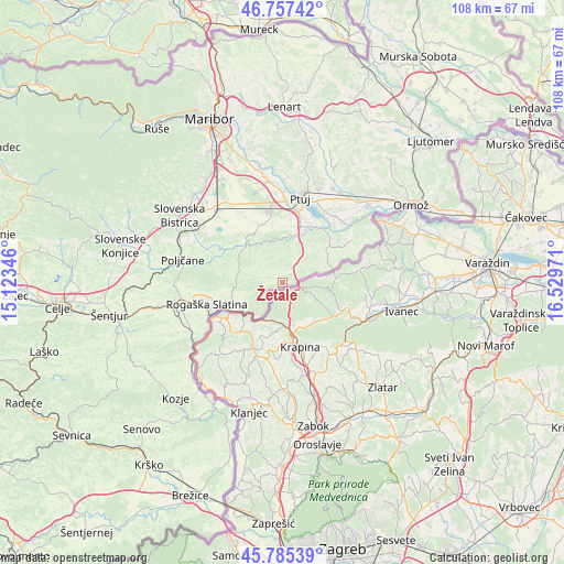
Žetale GPS coordinates[2]
46° 16' 24.816" North, 15° 49' 35.688" East
| Map corner | latitude | longitude |
|---|---|---|
| Upper-left | 46.75742°, | 15.12346° |
| Center: | 46.27356°, | 15.82658° |
| Lower-right: | 45.78539°, | 16.52971° |
| Map W x H: | 108.1×108.1 km | = 67.2×67.2mi |
| max Lat: | 46.83694° ⇑48.3% North |
| Žetale: | 46.27356° |
| min Lat: | ⇓51.7% South 45.47667° |
| min Long | Žetale | max Long |
| 13.52639° | 15.82658° | 16.4975° |
| W 83.8%⇐ | ⇒16.2% E |
Elevation
Elevation of Žetale is 312 m = 1024 ft, and this is 13.6 m = 45 ft below average elevation for this country.
| Max E: |
1551 m = 5089 ft | 44.3% |
| Avg. | 325.6 m = 1068 ft | |
| Žetale | 312 m = 1024 ft | |
Min E: |
2 m = 7 ft | 55.7% |
See also: Slovenia elevation on elevation.city.
Geographical zone
Žetale is located in North temperate zone (between Tropic of Cancer and the Arctic Circle). Distance of this North polar circle is 2256 km =1401.8 mi to North.| Distance of | km | miles | from Žetale |
|---|---|---|---|
| North Pole | 4861.9 | 3021 | to North |
| Arctic Circle | 2256 | 1401.8 | to North |
| Tropic Cancer | 2539.2 | 1577.8 | to South |
| Equator | 5145.1 | 3197 | to South |


Nearby cities:
15 places around Žetale: (largest is in red/bold)
• Apače
11.6 km =7.2 mi,  350°
350°
• Draženci
12.3 km =7.6 mi,  8°
8°
• Kidričevo
14.7 km =9.1 mi, 349°
• Lancova Vas
11.1 km =6.9 mi, 11°
• Lovrenc na Dravskem Polju
11.7 km =7.3 mi,  341°
341°
• Majšperk
11.2 km =7 mi,  320°
320°
• Makole
13.2 km =8.2 mi,  291°
291°
• Njiverce
14.5 km =9 mi, 353°
• Pobrežje
13 km =8.1 mi,  17°
17°
• Podlehnik
8 km =5 mi,  30°
30°
• Rogatec
10.9 km =6.8 mi,  243°
243°
• Rogaška Slatina
14.9 km =9.3 mi,  254°
254°
• Spodnja Hajdina
15.1 km =9.4 mi, 5°
• Videm pri Ptuju
12.2 km =7.6 mi, 30°
• Zgornja Hajdina
14.8 km =9.2 mi,  3°
3°
Sources, notices
• [Note1] Compared only with cities in Slovenia existing in our database
• [Src1] Map data: © OpenStreetMap contributors (CC-BY-SA)
• [Src2] Other city data from geonames.org with taken over terms of usage.
• [Src3] Geographical zone / Annual Mean Temperature by Robert A. Rohde @ Wikipedia
