Krog geodata
Krog (Murska Sobota) is a populated place; located in Slovenia in Europe/Ljubljana (GMT+2) time zone. With population of 1,132 people, there are 190 cities with bigger population in this country. Compared to other cities in Slovenia, 94.5% of cities are located further ↓South; 92.3% of cities are located further ←West and 82.3% of cities have higher elevation than Krog. Note1


Krog GPS coordinates[2]
46° 38' 17.016" North, 16° 8' 29.004" East
| Map corner | latitude | longitude |
|---|---|---|
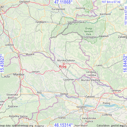
| Upper-left | 47.11868°, | 15.43827° |
| Center: | 46.63806°, | 16.14139° |
| Lower-right: | 46.15314°, | 16.84452° |
| Map W x H: | 107.4×107.4 km | = 66.7×66.7mi |
| max Lat: | 46.83694° ⇑5.5% North |
| Krog: | 46.63806° |
| min Lat: | ⇓94.5% South 45.47667° |
| min Long | Krog | max Long |
| 13.52639° | 16.14139° | 16.4975° |
| W 92.3%⇐ | ⇒7.7% E |
Elevation
Elevation of Krog is 188 m = 617 ft, and this is 137.6 m = 451 ft below average elevation for this country.
| Max E: |
1551 m = 5089 ft | 82.3% |
| Avg. | 325.6 m = 1068 ft | |
| Krog | 188 m = 617 ft | |
Min E: |
2 m = 7 ft | 17.7% |
See also: Slovenia elevation on elevation.city.
Geographical zone
Krog is located in North temperate zone (between Tropic of Cancer and the Arctic Circle). Distance of this North polar circle is 2215.5 km =1376.6 mi to North.| Distance of | km | miles | from Krog |
|---|---|---|---|
| North Pole | 4821.4 | 2995.9 | to North |
| Arctic Circle | 2215.5 | 1376.6 | to North |
| Tropic Cancer | 2579.7 | 1603 | to South |
| Equator | 5185.7 | 3222.2 | to South |


Nearby cities:
15 places around Krog: (largest is in red/bold)
• Bakovci
2.2 km =1.4 mi,  162°
162°
• Bratonci
6.3 km =3.9 mi,  110°
110°
• Dokležovje
4.8 km =3 mi,  144°
144°
• Križevci pri Ljutomeru
7.8 km =4.8 mi,  181°
181°
• Lipovci
6.7 km =4.2 mi,  99°
99°
• Martjanci
6.9 km =4.3 mi,  38°
38°
• Murska Sobota
3.3 km =2.1 mi, 35°
• Petanjci
6 km =3.7 mi,  286°
286°
• Puconci
7.7 km =4.8 mi,  8°
8°
• Pušča
2 km =1.2 mi,  354°
354°
• Rakičan
5 km =3.1 mi,  72°
72°
• Tišina
4.4 km =2.7 mi,  300°
300°
• Tropovci
3.4 km =2.1 mi, 300°
• Veržej
6.3 km =3.9 mi, 163°
• Černelavci
3.2 km =2 mi, 349°
Sources, notices
• [Note1] Compared only with cities in Slovenia existing in our database
• [Src1] Map data: © OpenStreetMap contributors (CC-BY-SA)
• [Src2] Other city data from geonames.org with taken over terms of usage.
• [Src3] Geographical zone / Annual Mean Temperature by Robert A. Rohde @ Wikipedia
