Černelavci geodata
Černelavci (Murska Sobota) is a populated place; located in Slovenia in Europe/Ljubljana (GMT+2) time zone. With population of 1,272 people, there are 168 cities with bigger population in this country. Compared to other cities in Slovenia, 96.7% of cities are located further ↓South; 91.8% of cities are located further ←West and 81.5% of cities have higher elevation than Černelavci. Note1


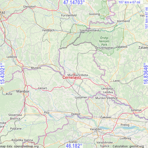
Černelavci GPS coordinates[2]
46° 40' 0.012" North, 16° 7' 59.988" East
| Map corner | latitude | longitude |
|---|---|---|
| Upper-left | 47.14703°, | 15.43021° |
| Center: | 46.66667°, | 16.13333° |
| Lower-right: | 46.182°, | 16.83646° |
| Map W x H: | 107.3×107.3 km | = 66.7×66.7mi |
| max Lat: | 46.83694° ⇑3.3% North |
| Černelavci: | 46.66667° |
| min Lat: | ⇓96.7% South 45.47667° |
| min Long | Černelavci | max Long |
| 13.52639° | 16.13333° | 16.4975° |
| W 91.8%⇐ | ⇒8.2% E |
Elevation
Elevation of Černelavci is 192 m = 630 ft, and this is 133.6 m = 438 ft below average elevation for this country.
| Max E: |
1551 m = 5089 ft | 81.5% |
| Avg. | 325.6 m = 1068 ft | |
| Černelavci | 192 m = 630 ft | |
Min E: |
2 m = 7 ft | 18.5% |
See also: Slovenia elevation on elevation.city.
Geographical zone
Černelavci is located in North temperate zone (between Tropic of Cancer and the Arctic Circle). Distance of this North polar circle is 2212.3 km =1374.7 mi to North.| Distance of | km | miles | from Černelavci |
|---|---|---|---|
| North Pole | 4818.2 | 2993.9 | to North |
| Arctic Circle | 2212.3 | 1374.7 | to North |
| Tropic Cancer | 2582.9 | 1604.9 | to South |
| Equator | 5188.8 | 3224.2 | to South |


Nearby cities:
15 places around Černelavci: (largest is in red/bold)
• Bakovci
5.5 km =3.4 mi,  166°
166°
• Bratonci
8.5 km =5.3 mi,  129°
129°
• Dokležovje
7.8 km =4.8 mi,  154°
154°
• Krog
3.2 km =2 mi, 169°
• Lipovci
8.4 km =5.2 mi,  120°
120°
• Martjanci
5.4 km =3.4 mi,  65°
65°
• Moravske Toplice
6.9 km =4.3 mi, 74°
• Murska Sobota
2.6 km =1.6 mi,  100°
100°
• Petanjci
5.3 km =3.3 mi,  253°
253°
• Puconci
4.8 km =3 mi,  21°
21°
• Pušča
1.3 km =0.8 mi,  160°
160°
• Radenci
7.8 km =4.8 mi, 249°
• Rakičan
5.7 km =3.5 mi,  107°
107°
• Tišina
3.3 km =2.1 mi, 253°
• Tropovci
2.7 km =1.7 mi,  237°
237°
Sources, notices
• [Note1] Compared only with cities in Slovenia existing in our database
• [Src1] Map data: © OpenStreetMap contributors (CC-BY-SA)
• [Src2] Other city data from geonames.org with taken over terms of usage.
• [Src3] Geographical zone / Annual Mean Temperature by Robert A. Rohde @ Wikipedia
