Radeče geodata
Radeče is a seat of a first-order administrative division; located in Slovenia in Europe/Ljubljana (GMT+2) time zone. With population of 2,168 people, there are 92 cities with bigger population in this country. Compared to other cities in Slovenia, 69.5% of cities are located further ↑North; 59.7% of cities are located further ←West and 80.3% of cities have higher elevation than Radeče. Note1


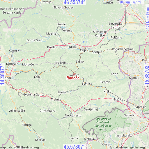
Radeče GPS coordinates[2]
46° 4' 5.016" North, 15° 11' 2.004" East
| Map corner | latitude | longitude |
|---|---|---|
| Upper-left | 46.55374°, | 14.48077° |
| Center: | 46.06806°, | 15.18389° |
| Lower-right: | 45.57807°, | 15.88702° |
| Map W x H: | 108.5×108.5 km | = 67.4×67.4mi |
| max Lat: | 46.83694° ⇑69.5% North |
| Radeče: | 46.06806° |
| min Lat: | ⇓30.5% South 45.47667° |
| min Long | Radeče | max Long |
| 13.52639° | 15.18389° | 16.4975° |
| W 59.7%⇐ | ⇒40.3% E |
Elevation
Elevation of Radeče is 196 m = 643 ft, and this is 129.6 m = 425 ft below average elevation for this country.
| Max E: |
1551 m = 5089 ft | 80.3% |
| Avg. | 325.6 m = 1068 ft | |
| Radeče | 196 m = 643 ft | |
Min E: |
2 m = 7 ft | 19.7% |
See also: Slovenia elevation on elevation.city.
Geographical zone
Radeče is located in North temperate zone (between Tropic of Cancer and the Arctic Circle). Distance of this North polar circle is 2278.9 km =1416 mi to North.| Distance of | km | miles | from Radeče |
|---|---|---|---|
| North Pole | 4884.8 | 3035.3 | to North |
| Arctic Circle | 2278.9 | 1416 | to North |
| Tropic Cancer | 2516.4 | 1563.6 | to South |
| Equator | 5122.3 | 3182.8 | to South |


Nearby cities:
15 places around Radeče: (largest is in red/bold)
• Dol pri Hrastniku
9.9 km =6.2 mi,  326°
326°
• Dolenji Boštanj
10.5 km =6.5 mi,  128°
128°
• Hrastnik
11.7 km =7.3 mi,  317°
317°
• Krmelj
9.3 km =5.8 mi,  177°
177°
• Laško
10.4 km =6.5 mi,  22°
22°
• Liboje
15.9 km =9.9 mi,  3°
3°
• Mirna
15.7 km =9.8 mi,  216°
216°
• Mokronog
15.3 km =9.5 mi,  192°
192°
• Rimske Toplice
6.1 km =3.8 mi,  5°
5°
• Sevnica
12.2 km =7.6 mi,  123°
123°
• Slovenska Vas
14.4 km =8.9 mi,  209°
209°
• Spodnja Rečica
11 km =6.8 mi, 12°
• Trbovlje
14 km =8.7 mi,  313°
313°
• Zagorje ob Savi
16.1 km =10 mi,  296°
296°
• Šentrupert
12.1 km =7.5 mi, 214°
Sources, notices
• [Note1] Compared only with cities in Slovenia existing in our database
• [Src1] Map data: © OpenStreetMap contributors (CC-BY-SA)
• [Src2] Other city data from geonames.org with taken over terms of usage.
• [Src3] Geographical zone / Annual Mean Temperature by Robert A. Rohde @ Wikipedia
