Bovec geodata
Bovec is a seat of a first-order administrative division; located in Slovenia in Europe/Ljubljana (GMT+2) time zone. With population of 1,631 people, there are 128 cities with bigger population in this country. Compared to other cities in Slovenia, 58.7% of cities are located further ↓South; 99.8% of cities are located further →East and 84.2% of cities have lower elevation than Bovec. Note1


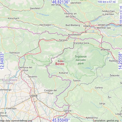
Bovec GPS coordinates[2]
46° 20' 17.088" North, 13° 33' 8.82" East
| Map corner | latitude | longitude |
|---|---|---|
| Upper-left | 46.82136°, | 12.84933° |
| Center: | 46.33808°, | 13.55245° |
| Lower-right: | 45.85049°, | 14.25558° |
| Map W x H: | 108×108 km | = 67.1×67.1mi |
| max Lat: | 46.83694° ⇑41.3% North |
| Bovec: | 46.33808° |
| min Lat: | ⇓58.7% South 45.47667° |
| min Long | Bovec | max Long |
| 13.52639° | 13.55245° | 16.4975° |
| W 0.2%⇐ | ⇒99.8% E |
Elevation
Elevation of Bovec is 465 m = 1526 ft, and this is 139.4 m = 457 ft above average elevation for this country.
| Max E: |
1551 m = 5089 ft | 15.8% |
| Bovec | 465 m 1526 ft | |
| Avg. | 325.6 m = 1068 ft | |
Min E: |
2 m = 7 ft | 84.2% |
See also: Slovenia elevation on elevation.city.
Geographical zone
Bovec is located in North temperate zone (between Tropic of Cancer and the Arctic Circle). Distance of this North polar circle is 2248.9 km =1397.4 mi to North.| Distance of | km | miles | from Bovec |
|---|---|---|---|
| North Pole | 4854.8 | 3016.6 | to North |
| Arctic Circle | 2248.9 | 1397.4 | to North |
| Tropic Cancer | 2546.4 | 1582.3 | to South |
| Equator | 5152.3 | 3201.5 | to South |


Nearby cities:
15 places around Bovec: (largest is in red/bold)
• Bohinjska Bistrica
31.7 km =19.7 mi,  103°
103°
• Deskle
32 km =19.9 mi,  171°
171°
• Dovje
35.3 km =21.9 mi,  65°
65°
• Gozd Martuljek
28.3 km =17.6 mi,  57°
57°
• Hrušica
37.6 km =23.4 mi, 71°
• Kanal
28.5 km =17.7 mi, 166°
• Kobarid
10.3 km =6.4 mi, 168°
• Kranjska Gora
21.8 km =13.5 mi,  52°
52°
• Mojstrana
26.5 km =16.5 mi, 68°
• Podbrdo
34.7 km =21.6 mi,  114°
114°
• Rateče
19.1 km =11.9 mi,  40°
40°
• Srednja Vas v Bohinju
28.9 km =18 mi, 99°
• Stara Fužina
22.5 km =14 mi,  93°
93°
• Tolmin
22.1 km =13.7 mi,  141°
141°
• Volče
21.7 km =13.5 mi,  146°
146°
Sources, notices
• [Note1] Compared only with cities in Slovenia existing in our database
• [Src1] Map data: © OpenStreetMap contributors (CC-BY-SA)
• [Src2] Other city data from geonames.org with taken over terms of usage.
• [Src3] Geographical zone / Annual Mean Temperature by Robert A. Rohde @ Wikipedia
