Nova Štifta geodata
Nova Štifta (Gornji Grad) is a populated place; located in Slovenia in Europe/Ljubljana (GMT+2) time zone. With population of 633 people, there are 407 cities with bigger population in this country. Compared to other cities in Slovenia, 52.2% of cities are located further ↓South; 55.7% of cities are located further →East and 90.7% of cities have lower elevation than Nova Štifta. Note1


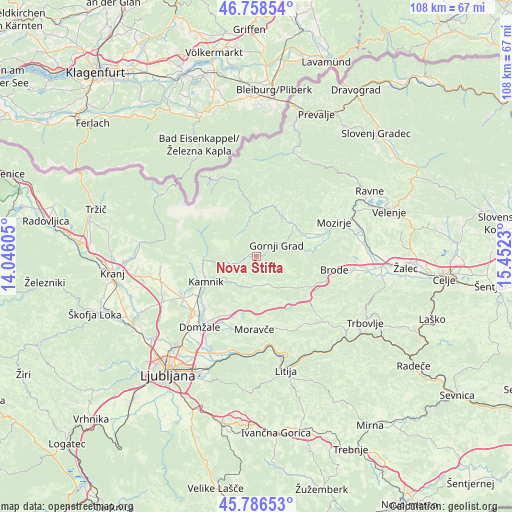
Nova Štifta GPS coordinates[2]
46° 16' 28.884" North, 14° 44' 57.012" East
| Map corner | latitude | longitude |
|---|---|---|
| Upper-left | 46.75854°, | 14.04605° |
| Center: | 46.27469°, | 14.74917° |
| Lower-right: | 45.78653°, | 15.4523° |
| Map W x H: | 108.1×108.1 km | = 67.2×67.2mi |
| max Lat: | 46.83694° ⇑47.8% North |
| Nova Štifta: | 46.27469° |
| min Lat: | ⇓52.2% South 45.47667° |
| min Long | Nova Štifta | max Long |
| 13.52639° | 14.74917° | 16.4975° |
| W 44.3%⇐ | ⇒55.7% E |
Elevation
Elevation of Nova Štifta is 538 m = 1765 ft, and this is 212.4 m = 697 ft above average elevation for this country.
| Max E: |
1551 m = 5089 ft | 9.3% |
| Nova Štifta | 538 m 1765 ft | |
| Avg. | 325.6 m = 1068 ft | |
Min E: |
2 m = 7 ft | 90.7% |
See also: Slovenia elevation on elevation.city.
Geographical zone
Nova Štifta is located in North temperate zone (between Tropic of Cancer and the Arctic Circle). Distance of this North polar circle is 2255.9 km =1401.8 mi to North.| Distance of | km | miles | from Nova Štifta |
|---|---|---|---|
| North Pole | 4861.8 | 3021 | to North |
| Arctic Circle | 2255.9 | 1401.8 | to North |
| Tropic Cancer | 2539.3 | 1577.8 | to South |
| Equator | 5145.3 | 3197.1 | to South |


Nearby cities:
15 places around Nova Štifta: (largest is in red/bold)
• Bočna
8.3 km =5.2 mi,  78°
78°
• Godič
10.9 km =6.8 mi,  259°
259°
• Gornji Grad
5.1 km =3.2 mi,  63°
63°
• Homec
15.3 km =9.5 mi,  228°
228°
• Kamnik
11.9 km =7.4 mi,  242°
242°
• Ljubno ob Savinji
10 km =6.2 mi,  40°
40°
• Lukovica pri Domžalah
12.5 km =7.8 mi,  200°
200°
• Luče
9.1 km =5.7 mi,  358°
358°
• Mekinje
11.2 km =7 mi,  245°
245°
• Moravče
15.3 km =9.5 mi,  181°
181°
• Podgorje
14.3 km =8.9 mi, 243°
• Prevoje pri Šentvidu
13.6 km =8.5 mi,  207°
207°
• Rečica ob Savinji
13.7 km =8.5 mi,  70°
70°
• Vrhpolje pri Kamniku
10 km =6.2 mi, 242°
• Šmarca
14.8 km =9.2 mi, 232°
Sources, notices
• [Note1] Compared only with cities in Slovenia existing in our database
• [Src1] Map data: © OpenStreetMap contributors (CC-BY-SA)
• [Src2] Other city data from geonames.org with taken over terms of usage.
• [Src3] Geographical zone / Annual Mean Temperature by Robert A. Rohde @ Wikipedia
