Žarnovica geodata
Žarnovica (Banskobystrický kraj) is a seat of a second-order administrative division; located in Slovakia in Europe/Bratislava (GMT+2) time zone. With population of 6,596 people, there are 92 cities with bigger population in this country. Compared to other cities in Slovakia, 70% of cities are located further ↑North; 59.4% of cities are located further →East and 57.1% of cities have higher elevation than Žarnovica. Note1
Administrative division(s):
- Level 1: Banskobystrický kraj
- Level 2: Okres Žarnovica
- Level 3: Žarnovica


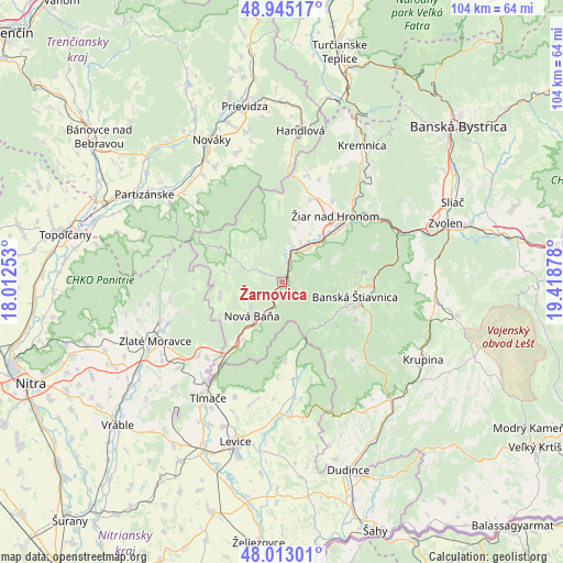
Žarnovica GPS coordinates[2]
48° 28' 52.428" North, 18° 42' 56.34" East
| Map corner | latitude | longitude |
|---|---|---|
| Upper-left | 48.94517°, | 18.01253° |
| Center: | 48.48123°, | 18.71565° |
| Lower-right: | 48.01301°, | 19.41878° |
| Map W x H: | 103.6×103.6 km | = 64.4×64.4mi |
| max Lat: | 49.43503° ⇑70% North |
| Žarnovica: | 48.48123° |
| min Lat: | ⇓30% South 47.76356° |
| min Long | Žarnovica | max Long |
| 16.9786° | 18.71565° | 22.18136° |
| W 40.6%⇐ | ⇒59.4% E |
Elevation
Elevation of Žarnovica is 230 m = 755 ft, and this is 106.1 m = 348 ft below average elevation for this country.
| Max E: |
1006 m = 3301 ft | 57.1% |
| Avg. | 336.1 m = 1103 ft | |
| Žarnovica | 230 m = 755 ft | |
Min E: |
102 m = 335 ft | 42.9% |
See also: Slovakia elevation on elevation.city.
Geographical zone
Žarnovica is located in North temperate zone (between Tropic of Cancer and the Arctic Circle). Distance of this North polar circle is 2010.6 km =1249.3 mi to North.| Distance of | km | miles | from Žarnovica |
|---|---|---|---|
| North Pole | 4616.5 | 2868.6 | to North |
| Arctic Circle | 2010.6 | 1249.3 | to North |
| Tropic Cancer | 2784.7 | 1730.3 | to South |
| Equator | 5390.6 | 3349.6 | to South |


Nearby cities:
15 places around Žarnovica: (largest is in red/bold)
• Banská Štiavnica
14.8 km =9.2 mi,  104°
104°
• Handlová
27.6 km =17.1 mi,  6°
6°
• Kováčová
31.5 km =19.6 mi,  64°
64°
• Kremnica
29 km =18 mi,  30°
30°
• Krupina
29.3 km =18.2 mi,  118°
118°
• Lehota pod Vtáčnikom
24.9 km =15.5 mi,  339°
339°
• Levice
30.6 km =19 mi,  195°
195°
• Nová Baňa
8.5 km =5.3 mi,  220°
220°
• Nováky
28.8 km =17.9 mi,  332°
332°
• Partizánske
29.4 km =18.3 mi,  303°
303°
• Svätý Anton
17.9 km =11.1 mi,  112°
112°
• Tlmače
25.3 km =15.7 mi,  212°
212°
• Voznica
2.6 km =1.6 mi, 207°
• Zlaté Moravce
25.6 km =15.9 mi,  245°
245°
• Žiar nad Hronom
15.8 km =9.8 mi,  38°
38°
Sources, notices
• [Note1] Compared only with cities in Slovakia existing in our database
• [Src1] Map data: © OpenStreetMap contributors (CC-BY-SA)
• [Src2] Other city data from geonames.org with taken over terms of usage.
• [Src3] Geographical zone / Annual Mean Temperature by Robert A. Rohde @ Wikipedia
