Banská Štiavnica geodata
Banská Štiavnica (Banskobystrický kraj) is a seat of a second-order administrative division; located in Slovakia in Europe/Bratislava (GMT+2) time zone. With population of 10,191 people, there are 69 cities with bigger population in this country. Compared to other cities in Slovakia, 71.2% of cities are located further ↑North; 52.9% of cities are located further →East and 80% of cities have lower elevation than Banská Štiavnica. Note1
Administrative division(s):
- Level 1: Banskobystrický kraj
- Level 2: Okres Banská Štiavnica
- Level 3: Banská Štiavnica


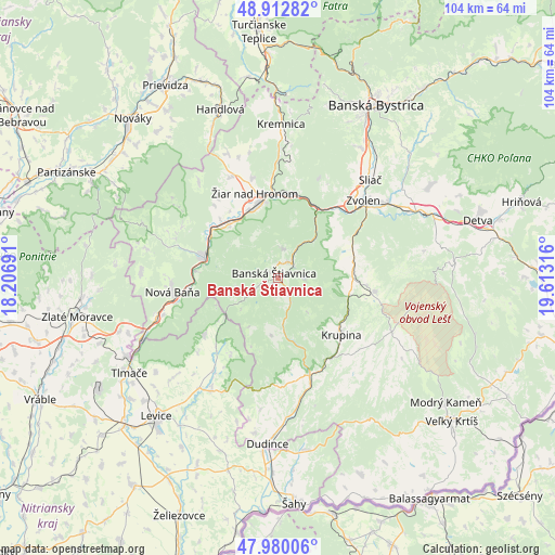
Banská Štiavnica GPS coordinates[2]
48° 26' 54.888" North, 18° 54' 36.108" East
| Map corner | latitude | longitude |
|---|---|---|
| Upper-left | 48.91282°, | 18.20691° |
| Center: | 48.44858°, | 18.91003° |
| Lower-right: | 47.98006°, | 19.61316° |
| Map W x H: | 103.7×103.7 km | = 64.4×64.4mi |
| max Lat: | 49.43503° ⇑71.2% North |
| Banská Štiavnica: | 48.44858° |
| min Lat: | ⇓28.8% South 47.76356° |
| min Long | Banská Štiavn | max Long |
| 16.9786° | 18.91003° | 22.18136° |
| W 47.1%⇐ | ⇒52.9% E |
Elevation
Elevation of Banská Štiavnica is 522 m = 1713 ft, and this is 185.9 m = 610 ft above average elevation for this country.
| Max E: |
1006 m = 3301 ft | 20% |
| Banská Štiavnica | 522 m 1713 ft | |
| Avg. | 336.1 m = 1103 ft | |
Min E: |
102 m = 335 ft | 80% |
See also: Slovakia elevation on elevation.city.
Geographical zone
Banská Štiavnica is located in North temperate zone (between Tropic of Cancer and the Arctic Circle). Distance of this North polar circle is 2014.2 km =1251.6 mi to North.| Distance of | km | miles | from Banská Štiavnica |
|---|---|---|---|
| North Pole | 4620.1 | 2870.8 | to North |
| Arctic Circle | 2014.2 | 1251.6 | to North |
| Tropic Cancer | 2781.1 | 1728.1 | to South |
| Equator | 5387 | 3347.3 | to South |


Nearby cities:
15 places around Banská Štiavnica: (largest is in red/bold)
• Banská Bystrica
37 km =23 mi,  28°
28°
• Dudince
30.9 km =19.2 mi,  183°
183°
• Handlová
32.9 km =20.4 mi,  340°
340°
• Kováčová
22.1 km =13.7 mi,  39°
39°
• Kremnica
28.5 km =17.7 mi,  1°
1°
• Krupina
15.4 km =9.6 mi,  132°
132°
• Lehota pod Vtáčnikom
35.4 km =22 mi,  319°
319°
• Levice
34.2 km =21.3 mi,  220°
220°
• Nová Baňa
20.1 km =12.5 mi,  261°
261°
• Svätý Anton
3.9 km =2.4 mi,  145°
145°
• Tlmače
33.1 km =20.6 mi,  237°
237°
• Voznica
15.6 km =9.7 mi,  274°
274°
• Zvolen
22.7 km =14.1 mi,  52°
52°
• Žarnovica
14.8 km =9.2 mi,  284°
284°
• Žiar nad Hronom
16.5 km =10.3 mi, 344°
Sources, notices
• [Note1] Compared only with cities in Slovakia existing in our database
• [Src1] Map data: © OpenStreetMap contributors (CC-BY-SA)
• [Src2] Other city data from geonames.org with taken over terms of usage.
• [Src3] Geographical zone / Annual Mean Temperature by Robert A. Rohde @ Wikipedia
