Handlová geodata
Handlová (Trenčiansky kraj) is a seat of a third-order administrative division; located in Slovakia in Europe/Bratislava (GMT+2) time zone. With population of 18,018 people, there are 44 cities with bigger population in this country. Compared to other cities in Slovakia, 52.9% of cities are located further ↑North; 57.6% of cities are located further →East and 69.4% of cities have lower elevation than Handlová. Note1


Handlová GPS coordinates[2]
48° 43' 39.36" North, 18° 45' 36.432" East
| Map corner | latitude | longitude |
|---|---|---|
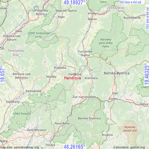
| Upper-left | 49.18927°, | 18.057° |
| Center: | 48.7276°, | 18.76012° |
| Lower-right: | 48.26165°, | 19.46325° |
| Map W x H: | 103.1×103.1 km | = 64.1×64.1mi |
| max Lat: | 49.43503° ⇑52.9% North |
| Handlová: | 48.7276° |
| min Lat: | ⇓47.1% South 47.76356° |
| min Long | Handlová | max Long |
| 16.9786° | 18.76012° | 22.18136° |
| W 42.4%⇐ | ⇒57.6% E |
Elevation
Elevation of Handlová is 424 m = 1391 ft, and this is 87.9 m = 288 ft above average elevation for this country.
| Max E: |
1006 m = 3301 ft | 30.6% |
| Handlová | 424 m 1391 ft | |
| Avg. | 336.1 m = 1103 ft | |
Min E: |
102 m = 335 ft | 69.4% |
See also: Slovakia elevation on elevation.city.
Geographical zone
Handlová is located in North temperate zone (between Tropic of Cancer and the Arctic Circle). Distance of this North polar circle is 1983.2 km =1232.3 mi to North.| Distance of | km | miles | from Handlová |
|---|---|---|---|
| North Pole | 4589.1 | 2851.5 | to North |
| Arctic Circle | 1983.2 | 1232.3 | to North |
| Tropic Cancer | 2812.1 | 1747.4 | to South |
| Equator | 5418 | 3366.6 | to South |


Nearby cities:
15 places around Handlová: (largest is in red/bold)
• Banská Bystrica
28.9 km =18 mi,  87°
87°
• Banská Štiavnica
32.9 km =20.4 mi,  160°
160°
• Bojnice
14.2 km =8.8 mi,  296°
296°
• Kováčová
28.8 km =17.9 mi,  119°
119°
• Kremnica
11.9 km =7.4 mi,  102°
102°
• Lehota pod Vtáčnikom
12.5 km =7.8 mi,  251°
251°
• Nová Baňa
35 km =21.7 mi,  194°
194°
• Nováky
16.7 km =10.4 mi,  263°
263°
• Partizánske
29.7 km =18.5 mi, 248°
• Prievidza
11 km =6.8 mi, 298°
• Turčianske Teplice
16.7 km =10.4 mi,  26°
26°
• Voznica
30 km =18.6 mi, 188°
• Zvolen
33.5 km =20.8 mi, 120°
• Žarnovica
27.6 km =17.1 mi, 186°
• Žiar nad Hronom
16.5 km =10.3 mi, 156°
Sources, notices
• [Note1] Compared only with cities in Slovakia existing in our database
• [Src1] Map data: © OpenStreetMap contributors (CC-BY-SA)
• [Src2] Other city data from geonames.org with taken over terms of usage.
• [Src3] Geographical zone / Annual Mean Temperature by Robert A. Rohde @ Wikipedia
