Lehota pod Vtáčnikom geodata
Lehota pod Vtáčnikom (Trenčiansky kraj) is a seat of a third-order administrative division; located in Slovakia in Europe/Bratislava (GMT+2) time zone. With population of 3,929 people, there are 126 cities with bigger population in this country. Compared to other cities in Slovakia, 58.8% of cities are located further ↑North; 64.1% of cities are located further →East and 64.1% of cities have lower elevation than Lehota pod Vtáčnikom. Note1
Administrative division(s):
- Level 1: Trenčiansky kraj
- Level 2: Okres Prievidza
- Level 3: Lehota pod Vtáčnikom


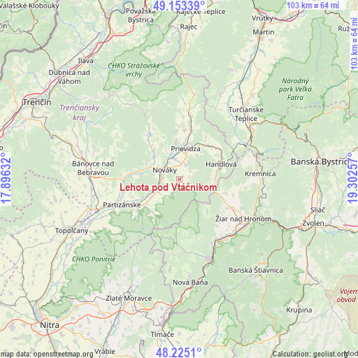
Lehota pod Vtáčnikom GPS coordinates[2]
48° 41' 28.968" North, 18° 35' 57.984" East
| Map corner | latitude | longitude |
|---|---|---|
| Upper-left | 49.15339°, | 17.89632° |
| Center: | 48.69138°, | 18.59944° |
| Lower-right: | 48.2251°, | 19.30257° |
| Map W x H: | 103.2×103.2 km | = 64.1×64.1mi |
| max Lat: | 49.43503° ⇑58.8% North |
| Lehota pod Vtáčnikom: | 48.69138° |
| min Lat: | ⇓41.2% South 47.76356° |
| min Long | Lehota pod Vtá | max Long |
| 16.9786° | 18.59944° | 22.18136° |
| W 35.9%⇐ | ⇒64.1% E |
Elevation
Elevation of Lehota pod Vtáčnikom is 385 m = 1263 ft, and this is 48.9 m = 160 ft above average elevation for this country.
| Max E: |
1006 m = 3301 ft | 35.9% |
| Lehota pod Vtáčnikom | 385 m 1263 ft | |
| Avg. | 336.1 m = 1103 ft | |
Min E: |
102 m = 335 ft | 64.1% |
See also: Slovakia elevation on elevation.city.
Geographical zone
Lehota pod Vtáčnikom is located in North temperate zone (between Tropic of Cancer and the Arctic Circle). Distance of this North polar circle is 1987.2 km =1234.8 mi to North.| Distance of | km | miles | from Lehota pod Vtáčnikom |
|---|---|---|---|
| North Pole | 4593.1 | 2854 | to North |
| Arctic Circle | 1987.2 | 1234.8 | to North |
| Tropic Cancer | 2808.1 | 1744.9 | to South |
| Equator | 5414 | 3364.1 | to South |


Nearby cities:
15 places around Lehota pod Vtáčnikom: (largest is in red/bold)
• Banská Štiavnica
35.4 km =22 mi,  139°
139°
• Bojnice
10.5 km =6.5 mi,  354°
354°
• Bánovce nad Bebravou
25.3 km =15.7 mi,  277°
277°
• Handlová
12.5 km =7.8 mi,  71°
71°
• Kremnica
23.5 km =14.6 mi,  86°
86°
• Nová Baňa
30 km =18.6 mi,  174°
174°
• Nováky
5.3 km =3.3 mi,  294°
294°
• Partizánske
17.3 km =10.7 mi,  246°
246°
• Prievidza
9.5 km =5.9 mi,  12°
12°
• Topoľčany
34.8 km =21.6 mi, 245°
• Turčianske Teplice
27 km =16.8 mi,  45°
45°
• Voznica
26.7 km =16.6 mi,  164°
164°
• Zlaté Moravce
37 km =23 mi,  203°
203°
• Žarnovica
24.9 km =15.5 mi, 159°
• Žiar nad Hronom
21.5 km =13.4 mi,  121°
121°
Sources, notices
• [Note1] Compared only with cities in Slovakia existing in our database
• [Src1] Map data: © OpenStreetMap contributors (CC-BY-SA)
• [Src2] Other city data from geonames.org with taken over terms of usage.
• [Src3] Geographical zone / Annual Mean Temperature by Robert A. Rohde @ Wikipedia
