Lučenec geodata
Lučenec (Banskobystrický kraj) is a seat of a second-order administrative division; located in Slovakia in Europe/Bratislava (GMT+2) time zone. With population of 28,159 people, there are 23 cities with bigger population in this country. Compared to other cities in Slovakia, 78.8% of cities are located further ↑North; 67.1% of cities are located further ←West and 68.8% of cities have higher elevation than Lučenec. Note1


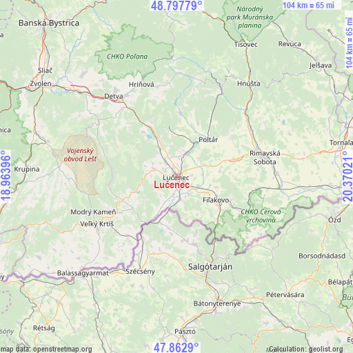
Lučenec GPS coordinates[2]
48° 19' 56.964" North, 19° 40' 1.488" East
| Map corner | latitude | longitude |
|---|---|---|
| Upper-left | 48.79779°, | 18.96396° |
| Center: | 48.33249°, | 19.66708° |
| Lower-right: | 47.8629°, | 20.37021° |
| Map W x H: | 104×103.9 km | = 64.6×64.6mi |
| max Lat: | 49.43503° ⇑78.8% North |
| Lučenec: | 48.33249° |
| min Lat: | ⇓21.2% South 47.76356° |
| min Long | Lučenec | max Long |
| 16.9786° | 19.66708° | 22.18136° |
| W 67.1%⇐ | ⇒32.9% E |
Elevation
Elevation of Lučenec is 187 m = 614 ft, and this is 149.1 m = 489 ft below average elevation for this country.
| Max E: |
1006 m = 3301 ft | 68.8% |
| Avg. | 336.1 m = 1103 ft | |
| Lučenec | 187 m = 614 ft | |
Min E: |
102 m = 335 ft | 31.2% |
See also: Slovakia elevation on elevation.city.
Geographical zone
Lučenec is located in North temperate zone (between Tropic of Cancer and the Arctic Circle). Distance of this North polar circle is 2027.1 km =1259.6 mi to North.| Distance of | km | miles | from Lučenec |
|---|---|---|---|
| North Pole | 4633 | 2878.8 | to North |
| Arctic Circle | 2027.1 | 1259.6 | to North |
| Tropic Cancer | 2768.2 | 1720.1 | to South |
| Equator | 5374.1 | 3339.3 | to South |


Nearby cities:
15 places around Lučenec: (largest is in red/bold)
• Brezno
52.5 km =32.6 mi,  357°
357°
• Detva
31.3 km =19.4 mi,  324°
324°
• Fiľakovo
13.7 km =8.5 mi,  121°
121°
• Hriňová
29.2 km =18.1 mi,  339°
339°
• Hrochoť,Slovakia
44.4 km =27.6 mi, 324°
• Kováčová
51.3 km =31.9 mi,  305°
305°
• Krupina
44.6 km =27.7 mi,  273°
273°
• Poltár
14.4 km =8.9 mi,  40°
40°
• Revúca
51.2 km =31.8 mi, 40°
• Rimavská Sobota
26.8 km =16.7 mi,  77°
77°
• Svätý Anton
54.6 km =33.9 mi,  280°
280°
• Tisovec
43.4 km =27 mi,  27°
27°
• Veľký Krtíš
27.1 km =16.8 mi,  239°
239°
• Zvolen
46.5 km =28.9 mi, 305°
• Čierny Balog
46.1 km =28.6 mi, 358°
Sources, notices
• [Note1] Compared only with cities in Slovakia existing in our database
• [Src1] Map data: © OpenStreetMap contributors (CC-BY-SA)
• [Src2] Other city data from geonames.org with taken over terms of usage.
• [Src3] Geographical zone / Annual Mean Temperature by Robert A. Rohde @ Wikipedia
