Bytča geodata
Bytča (Žilinský kraj) is a seat of a second-order administrative division; located in Slovakia in Europe/Bratislava (GMT+2) time zone. With population of 11,279 people, there are 63 cities with bigger population in this country. Compared to other cities in Slovakia, 88.8% of cities are located further ↓South; 65.3% of cities are located further →East and 55.3% of cities have lower elevation than Bytča. Note1


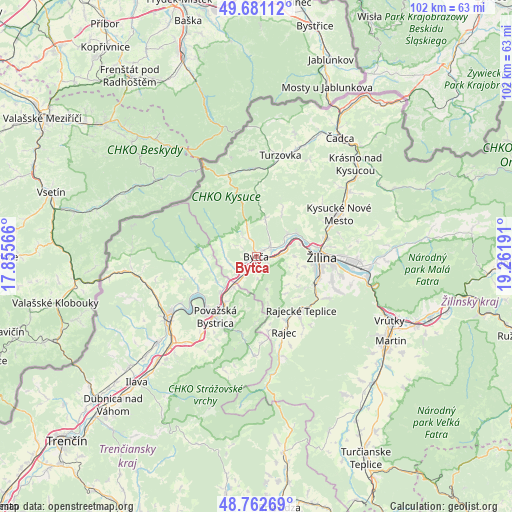
Bytča GPS coordinates[2]
49° 13' 26.544" North, 18° 33' 31.608" East
| Map corner | latitude | longitude |
|---|---|---|
| Upper-left | 49.68112°, | 17.85566° |
| Center: | 49.22404°, | 18.55878° |
| Lower-right: | 48.76269°, | 19.26191° |
| Map W x H: | 102.1×102.1 km | = 63.4×63.4mi |
| max Lat: | 49.43503° ⇑11.2% North |
| Bytča: | 49.22404° |
| min Lat: | ⇓88.8% South 47.76356° |
| min Long | Bytča | max Long |
| 16.9786° | 18.55878° | 22.18136° |
| W 34.7%⇐ | ⇒65.3% E |
Elevation
Elevation of Bytča is 307 m = 1007 ft, and this is 29.1 m = 95 ft below average elevation for this country.
| Max E: |
1006 m = 3301 ft | 44.7% |
| Avg. | 336.1 m = 1103 ft | |
| Bytča | 307 m = 1007 ft | |
Min E: |
102 m = 335 ft | 55.3% |
See also: Slovakia elevation on elevation.city.
Geographical zone
Bytča is located in North temperate zone (between Tropic of Cancer and the Arctic Circle). Distance of this North polar circle is 1928 km =1198 mi to North.| Distance of | km | miles | from Bytča |
|---|---|---|---|
| North Pole | 4533.9 | 2817.2 | to North |
| Arctic Circle | 1928 | 1198 | to North |
| Tropic Cancer | 2867.3 | 1781.7 | to South |
| Equator | 5473.2 | 3400.9 | to South |


Nearby cities:
15 places around Bytča: (largest is in red/bold)
• Dubnica nad Váhom
41 km =25.5 mi,  224°
224°
• Ilava
34.5 km =21.4 mi, 223°
• Krasňany
23.9 km =14.9 mi,  92°
92°
• Kysucké Nové Mesto
18.4 km =11.4 mi,  62°
62°
• Martin
31.8 km =19.8 mi,  123°
123°
• Nemšová
42.9 km =26.7 mi,  228°
228°
• Považská Bystrica
15.1 km =9.4 mi, 221°
• Púchov
20.2 km =12.6 mi,  236°
236°
• Rajec
16.1 km =10 mi,  158°
158°
• Stráža
25.3 km =15.7 mi, 89°
• Terchová
34.4 km =21.4 mi,  83°
83°
• Turzovka
20.6 km =12.8 mi,  12°
12°
• Vrútky
28.8 km =17.9 mi, 115°
• Čadca
28.8 km =17.9 mi,  35°
35°
• Žilina
13.1 km =8.1 mi, 90°
Sources, notices
• [Note1] Compared only with cities in Slovakia existing in our database
• [Src1] Map data: © OpenStreetMap contributors (CC-BY-SA)
• [Src2] Other city data from geonames.org with taken over terms of usage.
• [Src3] Geographical zone / Annual Mean Temperature by Robert A. Rohde @ Wikipedia
