Považská Bystrica geodata
Považská Bystrica (Trenčiansky kraj) is a seat of a second-order administrative division; located in Slovakia in Europe/Bratislava (GMT+2) time zone. With population of 43,936 people, there are 12 cities with bigger population in this country. Compared to other cities in Slovakia, 79.4% of cities are located further ↓South; 67.6% of cities are located further →East and 51.8% of cities have lower elevation than Považská Bystrica. Note1
Administrative division(s):
- Level 1: Trenčiansky kraj
- Level 2: Okres Považská Bystrica
- Level 3: Považská Bystrica


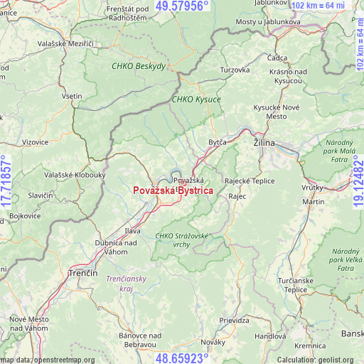
Považská Bystrica GPS coordinates[2]
49° 7' 17.508" North, 18° 25' 18.084" East
| Map corner | latitude | longitude |
|---|---|---|
| Upper-left | 49.57956°, | 17.71857° |
| Center: | 49.12153°, | 18.42169° |
| Lower-right: | 48.65923°, | 19.12482° |
| Map W x H: | 102.3×102.3 km | = 63.6×63.6mi |
| max Lat: | 49.43503° ⇑20.6% North |
| Považská Bystrica: | 49.12153° |
| min Lat: | ⇓79.4% South 47.76356° |
| min Long | Považská Byst | max Long |
| 16.9786° | 18.42169° | 22.18136° |
| W 32.4%⇐ | ⇒67.6% E |
Elevation
Elevation of Považská Bystrica is 280 m = 919 ft, and this is 56.1 m = 184 ft below average elevation for this country.
| Max E: |
1006 m = 3301 ft | 48.2% |
| Avg. | 336.1 m = 1103 ft | |
| Považská Bystrica | 280 m = 919 ft | |
Min E: |
102 m = 335 ft | 51.8% |
See also: Považská Bystrica elevation on elevation.city.
Geographical zone
Považská Bystrica is located in North temperate zone (between Tropic of Cancer and the Arctic Circle). Distance of this North polar circle is 1939.4 km =1205.1 mi to North.| Distance of | km | miles | from Považská Bystrica |
|---|---|---|---|
| North Pole | 4545.3 | 2824.3 | to North |
| Arctic Circle | 1939.4 | 1205.1 | to North |
| Tropic Cancer | 2855.9 | 1774.6 | to South |
| Equator | 5461.8 | 3393.8 | to South |


Nearby cities:
15 places around Považská Bystrica: (largest is in red/bold)
• Bytča
15.1 km =9.4 mi,  41°
41°
• Dubnica nad Váhom
25.9 km =16.1 mi,  225°
225°
• Ilava
19.3 km =12 mi,  224°
224°
• Krasňany
35.4 km =22 mi,  72°
72°
• Kysucké Nové Mesto
32.9 km =20.4 mi,  52°
52°
• Martin
37.1 km =23.1 mi,  99°
99°
• Nemšová
28 km =17.4 mi, 232°
• Nová Dubnica
28.9 km =18 mi, 224°
• Púchov
7 km =4.3 mi,  273°
273°
• Rajec
16.3 km =10.1 mi, 102°
• Stráža
37.2 km =23.1 mi, 71°
• Trenčianske Teplice
29.9 km =18.6 mi, 218°
• Turzovka
34.7 km =21.6 mi,  24°
24°
• Vrútky
36.1 km =22.4 mi,  91°
91°
• Žilina
25.7 km =16 mi,  63°
63°
Sources, notices
• [Note1] Compared only with cities in Slovakia existing in our database
• [Src1] Map data: © OpenStreetMap contributors (CC-BY-SA)
• [Src2] Other city data from geonames.org with taken over terms of usage.
• [Src3] Geographical zone / Annual Mean Temperature by Robert A. Rohde @ Wikipedia
