Topoľčany geodata
Topoľčany (Nitriansky kraj) is a seat of a second-order administrative division; located in Slovakia in Europe/Bratislava (GMT+1) time zone. In our database, there are 168 cities with bigger population. Compared to other cities in Slovakia, 68.2% of cities are located further ↑North; 73.5% of cities are located further →East and 73.5% of cities have higher elevation than Topoľčany. Note1


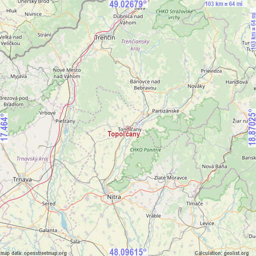
Topoľčany GPS coordinates[2]
48° 33' 48.996" North, 18° 10' 1.632" East
| Map corner | latitude | longitude |
|---|---|---|
| Upper-left | 49.02679°, | 17.464° |
| Center: | 48.56361°, | 18.16712° |
| Lower-right: | 48.09615°, | 18.87025° |
| Map W x H: | 103.5×103.5 km | = 64.3×64.3mi |
| max Lat: | 49.43503° ⇑68.2% North |
| Topoľčany: | 48.56361° |
| min Lat: | ⇓31.8% South 47.76356° |
| min Long | Topoľčany | max Long |
| 16.9786° | 18.16712° | 22.18136° |
| W 26.5%⇐ | ⇒73.5% E |
Elevation
Elevation of Topoľčany is 174 m = 571 ft, and this is 162.1 m = 532 ft below average elevation for this country.
| Max E: |
1006 m = 3301 ft | 73.5% |
| Avg. | 336.1 m = 1103 ft | |
| Topoľčany | 174 m = 571 ft | |
Min E: |
102 m = 335 ft | 26.5% |
See also: Slovakia elevation on elevation.city.
Geographical zone
Topoľčany is located in North temperate zone (between Tropic of Cancer and the Arctic Circle). Distance of this North polar circle is 2001.4 km =1243.6 mi to North.| Distance of | km | miles | from Topoľčany |
|---|---|---|---|
| North Pole | 4607.3 | 2862.8 | to North |
| Arctic Circle | 2001.4 | 1243.6 | to North |
| Tropic Cancer | 2793.8 | 1736 | to South |
| Equator | 5399.8 | 3355.3 | to South |


Nearby cities:
15 places around Topoľčany: (largest is in red/bold)
• Bánovce nad Bebravou
18.7 km =11.6 mi,  20°
20°
• Hlohovec
30.6 km =19 mi,  241°
241°
• Lehota pod Vtáčnikom
34.8 km =21.6 mi,  65°
65°
• Leopoldov
32.4 km =20.1 mi,  246°
246°
• Nitra
29.1 km =18.1 mi,  192°
192°
• Nová Baňa
38.2 km =23.7 mi,  114°
114°
• Nováky
31.5 km =19.6 mi,  58°
58°
• Nové Mesto nad Váhom
32.8 km =20.4 mi,  311°
311°
• Partizánske
17.5 km =10.9 mi, 65°
• Piešťany
25.3 km =15.7 mi,  277°
277°
• Trenčín
37.9 km =23.5 mi,  346°
346°
• Vrbové
33.3 km =20.7 mi, 280°
• Vráble
37.1 km =23.1 mi,  163°
163°
• Zlaté Moravce
26.2 km =16.3 mi,  138°
138°
• Čachtice
32.5 km =20.2 mi,  300°
300°
Sources, notices
• [Note1] Compared only with cities in Slovakia existing in our database
• [Src1] Map data: © OpenStreetMap contributors (CC-BY-SA)
• [Src2] Other city data from geonames.org with taken over terms of usage.
• [Src3] Geographical zone / Annual Mean Temperature by Robert A. Rohde @ Wikipedia
