Hlohovec geodata
Hlohovec (Trnavský kraj) is a seat of a second-order administrative division; located in Slovakia in Europe/Bratislava (GMT+2) time zone. With population of 23,930 people, there are 29 cities with bigger population in this country. Compared to other cities in Slovakia, 72.9% of cities are located further ↑North; 81.8% of cities are located further →East and 82.4% of cities have higher elevation than Hlohovec. Note1


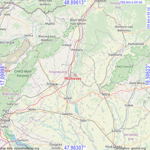
Hlohovec GPS coordinates[2]
48° 25' 54.264" North, 17° 48' 11.16" East
| Map corner | latitude | longitude |
|---|---|---|
| Upper-left | 48.89613°, | 17.09998° |
| Center: | 48.43174°, | 17.8031° |
| Lower-right: | 47.96307°, | 18.50623° |
| Map W x H: | 103.7×103.7 km | = 64.4×64.4mi |
| max Lat: | 49.43503° ⇑72.9% North |
| Hlohovec: | 48.43174° |
| min Lat: | ⇓27.1% South 47.76356° |
| min Long | Hlohovec | max Long |
| 16.9786° | 17.8031° | 22.18136° |
| W 18.2%⇐ | ⇒81.8% E |
Elevation
Elevation of Hlohovec is 144 m = 472 ft, and this is 192.1 m = 630 ft below average elevation for this country.
| Max E: |
1006 m = 3301 ft | 82.4% |
| Avg. | 336.1 m = 1103 ft | |
| Hlohovec | 144 m = 472 ft | |
Min E: |
102 m = 335 ft | 17.6% |
See also: Slovakia elevation on elevation.city.
Geographical zone
Hlohovec is located in North temperate zone (between Tropic of Cancer and the Arctic Circle). Distance of this North polar circle is 2016.1 km =1252.7 mi to North.| Distance of | km | miles | from Hlohovec |
|---|---|---|---|
| North Pole | 4622 | 2872 | to North |
| Arctic Circle | 2016.1 | 1252.7 | to North |
| Tropic Cancer | 2779.2 | 1726.9 | to South |
| Equator | 5385.1 | 3346.1 | to South |


Nearby cities:
15 places around Hlohovec: (largest is in red/bold)
• Brezová pod Bradlom
32.3 km =20.1 mi,  322°
322°
• Galanta
27.5 km =17.1 mi,  191°
191°
• Leopoldov
3.2 km =2 mi,  298°
298°
• Modra
38.2 km =23.7 mi,  253°
253°
• Nitra
25 km =15.5 mi,  123°
123°
• Nové Mesto nad Váhom
36.3 km =22.6 mi,  3°
3°
• Piešťany
18.2 km =11.3 mi,  5°
5°
• Senec
38 km =23.6 mi,  231°
231°
• Sládkovičovo
28.4 km =17.6 mi,  205°
205°
• Smolenice
28.6 km =17.8 mi,  286°
286°
• Topoľčany
30.6 km =19 mi,  61°
61°
• Trnava
17 km =10.6 mi, 249°
• Vrbové
21.7 km =13.5 mi,  344°
344°
• Čachtice
31.2 km =19.4 mi,  357°
357°
• Šaľa
31.7 km =19.7 mi,  169°
169°
Sources, notices
• [Note1] Compared only with cities in Slovakia existing in our database
• [Src1] Map data: © OpenStreetMap contributors (CC-BY-SA)
• [Src2] Other city data from geonames.org with taken over terms of usage.
• [Src3] Geographical zone / Annual Mean Temperature by Robert A. Rohde @ Wikipedia
