Piešťany geodata
Piešťany (Trnavský kraj) is a seat of a second-order administrative division; located in Slovakia in Europe/Bratislava (GMT+2) time zone. With population of 30,000 people, there are 22 cities with bigger population in this country. Compared to other cities in Slovakia, 65.9% of cities are located further ↑North; 81.2% of cities are located further →East and 77.1% of cities have higher elevation than Piešťany. Note1


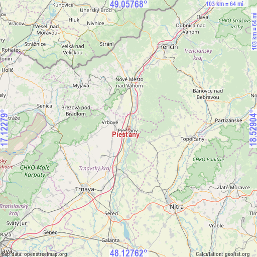
Piešťany GPS coordinates[2]
48° 35' 41.244" North, 17° 49' 33.276" East
| Map corner | latitude | longitude |
|---|---|---|
| Upper-left | 49.05768°, | 17.12279° |
| Center: | 48.59479°, | 17.82591° |
| Lower-right: | 48.12762°, | 18.52904° |
| Map W x H: | 103.4×103.4 km | = 64.2×64.2mi |
| max Lat: | 49.43503° ⇑65.9% North |
| Piešťany: | 48.59479° |
| min Lat: | ⇓34.1% South 47.76356° |
| min Long | Piešťany | max Long |
| 16.9786° | 17.82591° | 22.18136° |
| W 18.8%⇐ | ⇒81.2% E |
Elevation
Elevation of Piešťany is 161 m = 528 ft, and this is 175.1 m = 574 ft below average elevation for this country.
| Max E: |
1006 m = 3301 ft | 77.1% |
| Avg. | 336.1 m = 1103 ft | |
| Piešťany | 161 m = 528 ft | |
Min E: |
102 m = 335 ft | 22.9% |
See also: Slovakia elevation on elevation.city.
Geographical zone
Piešťany is located in North temperate zone (between Tropic of Cancer and the Arctic Circle). Distance of this North polar circle is 1997.9 km =1241.4 mi to North.| Distance of | km | miles | from Piešťany |
|---|---|---|---|
| North Pole | 4603.8 | 2860.7 | to North |
| Arctic Circle | 1997.9 | 1241.4 | to North |
| Tropic Cancer | 2797.3 | 1738.2 | to South |
| Equator | 5403.2 | 3357.4 | to South |


Nearby cities:
15 places around Piešťany: (largest is in red/bold)
• Brezová pod Bradlom
22.4 km =13.9 mi,  289°
289°
• Bánovce nad Bebravou
34.7 km =21.6 mi,  66°
66°
• Hlohovec
18.2 km =11.3 mi,  185°
185°
• Leopoldov
17.2 km =10.7 mi,  195°
195°
• Myjava
26.3 km =16.3 mi,  313°
313°
• Nitra
37.2 km =23.1 mi,  149°
149°
• Nové Mesto nad Váhom
18.1 km =11.2 mi,  1°
1°
• Senica
35 km =21.7 mi, 285°
• Smolenice
30.8 km =19.1 mi,  251°
251°
• Stará Turá
22.5 km =14 mi,  334°
334°
• Topoľčany
25.3 km =15.7 mi,  97°
97°
• Trenčín
37 km =23 mi,  25°
25°
• Trnava
29.9 km =18.6 mi,  216°
216°
• Vrbové
8.1 km =5 mi, 290°
• Čachtice
13.4 km =8.3 mi,  347°
347°
Sources, notices
• [Note1] Compared only with cities in Slovakia existing in our database
• [Src1] Map data: © OpenStreetMap contributors (CC-BY-SA)
• [Src2] Other city data from geonames.org with taken over terms of usage.
• [Src3] Geographical zone / Annual Mean Temperature by Robert A. Rohde @ Wikipedia
