Leopoldov geodata
Leopoldov (Trnavský kraj) is a populated place; located in Slovakia in Europe/Bratislava (GMT+2) time zone. With population of 3,999 people, there are 125 cities with bigger population in this country. Compared to other cities in Slovakia, 71.8% of cities are located further ↑North; 83.5% of cities are located further →East and 84.1% of cities have higher elevation than Leopoldov. Note1


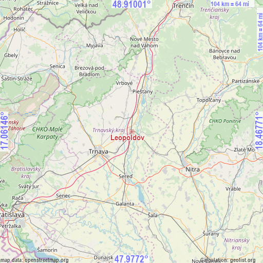
Leopoldov GPS coordinates[2]
48° 26' 44.7" North, 17° 45' 52.488" East
| Map corner | latitude | longitude |
|---|---|---|
| Upper-left | 48.91001°, | 17.06146° |
| Center: | 48.44575°, | 17.76458° |
| Lower-right: | 47.9772°, | 18.46771° |
| Map W x H: | 103.7×103.7 km | = 64.4×64.4mi |
| max Lat: | 49.43503° ⇑71.8% North |
| Leopoldov: | 48.44575° |
| min Lat: | ⇓28.2% South 47.76356° |
| min Long | Leopoldov | max Long |
| 16.9786° | 17.76458° | 22.18136° |
| W 16.5%⇐ | ⇒83.5% E |
Elevation
Elevation of Leopoldov is 143 m = 469 ft, and this is 193.1 m = 634 ft below average elevation for this country.
| Max E: |
1006 m = 3301 ft | 84.1% |
| Avg. | 336.1 m = 1103 ft | |
| Leopoldov | 143 m = 469 ft | |
Min E: |
102 m = 335 ft | 15.9% |
See also: Slovakia elevation on elevation.city.
Geographical zone
Leopoldov is located in North temperate zone (between Tropic of Cancer and the Arctic Circle). Distance of this North polar circle is 2014.5 km =1251.8 mi to North.| Distance of | km | miles | from Leopoldov |
|---|---|---|---|
| North Pole | 4620.4 | 2871 | to North |
| Arctic Circle | 2014.5 | 1251.8 | to North |
| Tropic Cancer | 2780.7 | 1727.8 | to South |
| Equator | 5386.7 | 3347.1 | to South |


Nearby cities:
15 places around Leopoldov: (largest is in red/bold)
• Brezová pod Bradlom
29.4 km =18.3 mi,  325°
325°
• Galanta
28.6 km =17.8 mi,  185°
185°
• Hlohovec
3.2 km =2 mi,  118°
118°
• Modra
36 km =22.4 mi,  249°
249°
• Nitra
28.2 km =17.5 mi, 123°
• Nové Mesto nad Váhom
35 km =21.7 mi,  8°
8°
• Piešťany
17.2 km =10.7 mi,  15°
15°
• Senec
36.8 km =22.9 mi,  226°
226°
• Sládkovičovo
28.7 km =17.8 mi,  198°
198°
• Smolenice
25.5 km =15.8 mi,  284°
284°
• Topoľčany
32.4 km =20.1 mi,  66°
66°
• Trnava
15.1 km =9.4 mi,  239°
239°
• Vrbové
19.6 km =12.2 mi,  350°
350°
• Čachtice
29.7 km =18.5 mi,  3°
3°
• Šaľa
33.8 km =21 mi,  165°
165°
Sources, notices
• [Note1] Compared only with cities in Slovakia existing in our database
• [Src1] Map data: © OpenStreetMap contributors (CC-BY-SA)
• [Src2] Other city data from geonames.org with taken over terms of usage.
• [Src3] Geographical zone / Annual Mean Temperature by Robert A. Rohde @ Wikipedia
