Čachtice geodata
Čachtice (Trenčiansky kraj) is a populated place; located in Slovakia in Europe/Bratislava (GMT+2) time zone. With population of 3,626 people, there are 129 cities with bigger population in this country. Compared to other cities in Slovakia, 55.3% of cities are located further ↑North; 82.4% of cities are located further →East and 70.6% of cities have higher elevation than Čachtice. Note1
Administrative division(s):
- Level 1: Trenčiansky kraj
- Level 2: Okres Nové Mesto nad Váhom
- Level 3: Čachtice


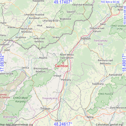
Čachtice GPS coordinates[2]
48° 42' 44.136" North, 17° 47' 13.344" East
| Map corner | latitude | longitude |
|---|---|---|
| Upper-left | 49.17407°, | 17.08392° |
| Center: | 48.71226°, | 17.78704° |
| Lower-right: | 48.24617°, | 18.49017° |
| Map W x H: | 103.2×103.2 km | = 64.1×64.1mi |
| max Lat: | 49.43503° ⇑55.3% North |
| Čachtice: | 48.71226° |
| min Lat: | ⇓44.7% South 47.76356° |
| min Long | Čachtice | max Long |
| 16.9786° | 17.78704° | 22.18136° |
| W 17.6%⇐ | ⇒82.4% E |
Elevation
Elevation of Čachtice is 181 m = 594 ft, and this is 155.1 m = 509 ft below average elevation for this country.
| Max E: |
1006 m = 3301 ft | 70.6% |
| Avg. | 336.1 m = 1103 ft | |
| Čachtice | 181 m = 594 ft | |
Min E: |
102 m = 335 ft | 29.4% |
See also: Slovakia elevation on elevation.city.
Geographical zone
Čachtice is located in North temperate zone (between Tropic of Cancer and the Arctic Circle). Distance of this North polar circle is 1984.9 km =1233.4 mi to North.| Distance of | km | miles | from Čachtice |
|---|---|---|---|
| North Pole | 4590.8 | 2852.6 | to North |
| Arctic Circle | 1984.9 | 1233.4 | to North |
| Tropic Cancer | 2810.4 | 1746.3 | to South |
| Equator | 5416.3 | 3365.5 | to South |


Nearby cities:
15 places around Čachtice: (largest is in red/bold)
• Brezová pod Bradlom
19 km =11.8 mi,  253°
253°
• Bánovce nad Bebravou
34.5 km =21.4 mi,  88°
88°
• Hlohovec
31.2 km =19.4 mi,  177°
177°
• Leopoldov
29.7 km =18.5 mi, 183°
• Myjava
16.8 km =10.4 mi,  287°
287°
• Nová Dubnica
36.1 km =22.4 mi,  46°
46°
• Nové Mesto nad Váhom
6 km =3.7 mi,  32°
32°
• Piešťany
13.4 km =8.3 mi,  167°
167°
• Senica
31 km =19.3 mi,  263°
263°
• Smolenice
34.9 km =21.7 mi,  228°
228°
• Stará Turá
9.9 km =6.2 mi,  316°
316°
• Topoľčany
32.5 km =20.2 mi,  120°
120°
• Trenčianske Teplice
35.5 km =22.1 mi, 51°
• Trenčín
27.7 km =17.2 mi,  42°
42°
• Vrbové
11.3 km =7 mi,  204°
204°
Sources, notices
• [Note1] Compared only with cities in Slovakia existing in our database
• [Src1] Map data: © OpenStreetMap contributors (CC-BY-SA)
• [Src2] Other city data from geonames.org with taken over terms of usage.
• [Src3] Geographical zone / Annual Mean Temperature by Robert A. Rohde @ Wikipedia
