Dunajská Streda geodata
Dunajská Streda (Trnavský kraj) is a populated place; located in Slovakia in Europe/Bratislava (GMT+2) time zone. With population of 23,639 people, there are 30 cities with bigger population in this country. Compared to other cities in Slovakia, 94.7% of cities are located further ↑North; 86.5% of cities are located further →East and 93.5% of cities have higher elevation than Dunajská Streda. Note1
Administrative division(s):
- Level 1: Trnavský kraj
- Level 2: Okres Dunajská Streda
- Level 3: Dunajská Streda


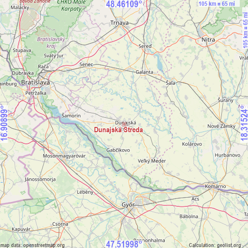
Dunajská Streda GPS coordinates[2]
47° 59' 33.648" North, 17° 36' 43.596" East
| Map corner | latitude | longitude |
|---|---|---|
| Upper-left | 48.46109°, | 16.90899° |
| Center: | 47.99268°, | 17.61211° |
| Lower-right: | 47.51998°, | 18.31524° |
| Map W x H: | 104.6×104.6 km | = 65×65mi |
| max Lat: | 49.43503° ⇑94.7% North |
| Dunajská Streda: | 47.99268° |
| min Lat: | ⇓5.3% South 47.76356° |
| min Long | Dunajská Stred | max Long |
| 16.9786° | 17.61211° | 22.18136° |
| W 13.5%⇐ | ⇒86.5% E |
Elevation
Elevation of Dunajská Streda is 117 m = 384 ft, and this is 219.1 m = 719 ft below average elevation for this country.
| Max E: |
1006 m = 3301 ft | 93.5% |
| Avg. | 336.1 m = 1103 ft | |
| Dunajská Streda | 117 m = 384 ft | |
Min E: |
102 m = 335 ft | 6.5% |
See also: Slovakia elevation on elevation.city.
Geographical zone
Dunajská Streda is located in North temperate zone (between Tropic of Cancer and the Arctic Circle). Distance of this North polar circle is 2064.9 km =1283.1 mi to North.| Distance of | km | miles | from Dunajská Streda |
|---|---|---|---|
| North Pole | 4670.8 | 2902.3 | to North |
| Arctic Circle | 2064.9 | 1283.1 | to North |
| Tropic Cancer | 2730.4 | 1696.6 | to South |
| Equator | 5336.3 | 3315.8 | to South |


Nearby cities:
15 places around Dunajská Streda: (largest is in red/bold)
• Bratislava
41.3 km =25.7 mi,  294°
294°
• Bratislava - Vajnory
38.2 km =23.7 mi,  308°
308°
• Dunajská Lužná
28 km =17.4 mi, 291°
• Gabčíkovo
11.5 km =7.1 mi,  192°
192°
• Galanta
23.6 km =14.7 mi,  21°
21°
• Ivanka pri Dunaji
34.2 km =21.3 mi, 309°
• Kolárovo
28.8 km =17.9 mi,  105°
105°
• Nové Zámky
40.9 km =25.4 mi,  91°
91°
• Senec
29.7 km =18.5 mi,  328°
328°
• Sládkovičovo
23.3 km =14.5 mi,  4°
4°
• Svätý Jur
41.2 km =25.6 mi, 314°
• Veľký Meder
19 km =11.8 mi,  142°
142°
• Vágfüzes
36.3 km =22.6 mi,  115°
115°
• Šamorín
22.9 km =14.2 mi,  280°
280°
• Šaľa
26.6 km =16.5 mi,  48°
48°
Sources, notices
• [Note1] Compared only with cities in Slovakia existing in our database
• [Src1] Map data: © OpenStreetMap contributors (CC-BY-SA)
• [Src2] Other city data from geonames.org with taken over terms of usage.
• [Src3] Geographical zone / Annual Mean Temperature by Robert A. Rohde @ Wikipedia
