Prešov geodata
Prešov (Prešovský kraj) is a seat of a first-order administrative division; located in Slovakia in Europe/Bratislava (GMT+2) time zone. With population of 94,718 people, there are 2 cities with bigger population in this country. Compared to other cities in Slovakia, 66.5% of cities are located further ↓South; 90% of cities are located further ←West and 52.9% of cities have higher elevation than Prešov. Note1


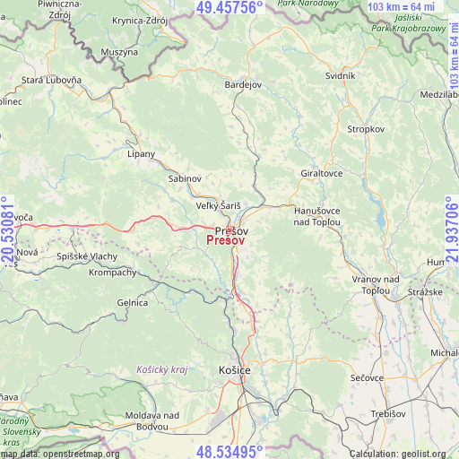
Prešov GPS coordinates[2]
48° 59' 54.204" North, 21° 14' 2.148" East
| Map corner | latitude | longitude |
|---|---|---|
| Upper-left | 49.45756°, | 20.53081° |
| Center: | 48.99839°, | 21.23393° |
| Lower-right: | 48.53495°, | 21.93706° |
| Map W x H: | 102.6×102.6 km | = 63.8×63.8mi |
| max Lat: | 49.43503° ⇑33.5% North |
| Prešov: | 48.99839° |
| min Lat: | ⇓66.5% South 47.76356° |
| min Long | Prešov | max Long |
| 16.9786° | 21.23393° | 22.18136° |
| W 90%⇐ | ⇒10% E |
Elevation
Elevation of Prešov is 247 m = 810 ft, and this is 89.1 m = 292 ft below average elevation for this country.
| Max E: |
1006 m = 3301 ft | 52.9% |
| Avg. | 336.1 m = 1103 ft | |
| Prešov | 247 m = 810 ft | |
Min E: |
102 m = 335 ft | 47.1% |
See also: Prešov elevation on elevation.city.
Geographical zone
Prešov is located in North temperate zone (between Tropic of Cancer and the Arctic Circle). Distance of this North polar circle is 1953.1 km =1213.6 mi to North.| Distance of | km | miles | from Prešov |
|---|---|---|---|
| North Pole | 4559 | 2832.8 | to North |
| Arctic Circle | 1953.1 | 1213.6 | to North |
| Tropic Cancer | 2842.2 | 1766.1 | to South |
| Equator | 5448.1 | 3385.3 | to South |


Nearby cities:
15 places around Prešov: (largest is in red/bold)
• Bardejov
32.7 km =20.3 mi,  4°
4°
• Bijacovce
31.8 km =19.8 mi,  275°
275°
• Gelnica
26.9 km =16.7 mi,  233°
233°
• Giraltovce
24.3 km =15.1 mi,  58°
58°
• Kavečany
24.8 km =15.4 mi,  184°
184°
• Košice
31.7 km =19.7 mi, 176°
• Krompachy
27.8 km =17.3 mi,  250°
250°
• Lipany
26.2 km =16.3 mi,  311°
311°
• Medzev
41.4 km =25.7 mi,  216°
216°
• Sabinov
15.2 km =9.4 mi,  319°
319°
• Spišské Podhradie
35.1 km =21.8 mi,  270°
270°
• Stropkov
37.9 km =23.5 mi,  53°
53°
• Svidník
42.2 km =26.2 mi,  35°
35°
• Vranov nad Topľou
35.1 km =21.8 mi,  110°
110°
• Žehra
32.3 km =20.1 mi, 266°
Sources, notices
• [Note1] Compared only with cities in Slovakia existing in our database
• [Src1] Map data: © OpenStreetMap contributors (CC-BY-SA)
• [Src2] Other city data from geonames.org with taken over terms of usage.
• [Src3] Geographical zone / Annual Mean Temperature by Robert A. Rohde @ Wikipedia
