Medzev geodata
Medzev (Košický kraj) is a populated place; located in Slovakia in Europe/Bratislava (GMT+2) time zone. With population of 3,667 people, there are 128 cities with bigger population in this country. Compared to other cities in Slovakia, 58.2% of cities are located further ↑North; 86.5% of cities are located further ←West and 56.5% of cities have lower elevation than Medzev. Note1


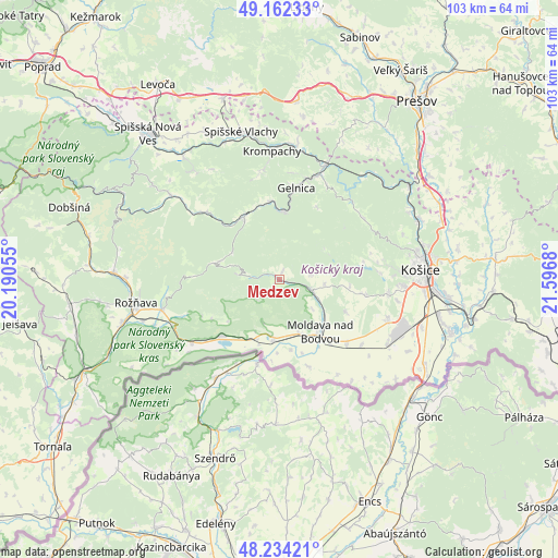
Medzev GPS coordinates[2]
48° 42' 1.476" North, 20° 53' 37.212" East
| Map corner | latitude | longitude |
|---|---|---|
| Upper-left | 49.16233°, | 20.19055° |
| Center: | 48.70041°, | 20.89367° |
| Lower-right: | 48.23421°, | 21.5968° |
| Map W x H: | 103.2×103.2 km | = 64.1×64.1mi |
| max Lat: | 49.43503° ⇑58.2% North |
| Medzev: | 48.70041° |
| min Lat: | ⇓41.8% South 47.76356° |
| min Long | Medzev | max Long |
| 16.9786° | 20.89367° | 22.18136° |
| W 86.5%⇐ | ⇒13.5% E |
Elevation
Elevation of Medzev is 316 m = 1037 ft, and this is 20.1 m = 66 ft below average elevation for this country.
| Max E: |
1006 m = 3301 ft | 43.5% |
| Avg. | 336.1 m = 1103 ft | |
| Medzev | 316 m = 1037 ft | |
Min E: |
102 m = 335 ft | 56.5% |
See also: Slovakia elevation on elevation.city.
Geographical zone
Medzev is located in North temperate zone (between Tropic of Cancer and the Arctic Circle). Distance of this North polar circle is 1986.2 km =1234.2 mi to North.| Distance of | km | miles | from Medzev |
|---|---|---|---|
| North Pole | 4592.1 | 2853.4 | to North |
| Arctic Circle | 1986.2 | 1234.2 | to North |
| Tropic Cancer | 2809.1 | 1745.5 | to South |
| Equator | 5415 | 3364.7 | to South |


Nearby cities:
15 places around Medzev: (largest is in red/bold)
• Betliar
28.3 km =17.6 mi,  270°
270°
• Bijacovce
36.6 km =22.7 mi,  349°
349°
• Dobšiná
40.7 km =25.3 mi,  289°
289°
• Gelnica
17.6 km =10.9 mi,  10°
10°
• Kavečany
24.4 km =15.2 mi,  69°
69°
• Košice
26.8 km =16.7 mi,  86°
86°
• Krompachy
23.8 km =14.8 mi,  356°
356°
• Levoča
42 km =26.1 mi,  328°
328°
• Moldava nad Bodvou
12.3 km =7.6 mi,  140°
140°
• Prešov
41.4 km =25.7 mi,  36°
36°
• Rožňava
26.5 km =16.5 mi,  260°
260°
• Sabinov
47.2 km =29.3 mi,  18°
18°
• Spišská Nová Ves
36.5 km =22.7 mi,  318°
318°
• Spišské Podhradie
35 km =21.7 mi,  342°
342°
• Žehra
31.9 km =19.8 mi, 346°
Sources, notices
• [Note1] Compared only with cities in Slovakia existing in our database
• [Src1] Map data: © OpenStreetMap contributors (CC-BY-SA)
• [Src2] Other city data from geonames.org with taken over terms of usage.
• [Src3] Geographical zone / Annual Mean Temperature by Robert A. Rohde @ Wikipedia
