Gelnica geodata
Gelnica (Košický kraj) is a seat of a second-order administrative division; located in Slovakia in Europe/Bratislava (GMT+2) time zone. With population of 6,404 people, there are 93 cities with bigger population in this country. Compared to other cities in Slovakia, 57.1% of cities are located further ↓South; 87.1% of cities are located further ←West and 62.4% of cities have lower elevation than Gelnica. Note1


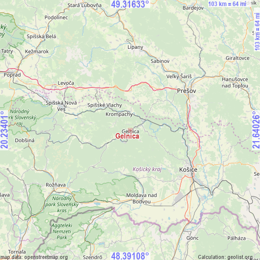
Gelnica GPS coordinates[2]
48° 51' 21.024" North, 20° 56' 13.668" East
| Map corner | latitude | longitude |
|---|---|---|
| Upper-left | 49.31633°, | 20.23401° |
| Center: | 48.85584°, | 20.93713° |
| Lower-right: | 48.39108°, | 21.64026° |
| Map W x H: | 102.9×102.9 km | = 63.9×63.9mi |
| max Lat: | 49.43503° ⇑42.9% North |
| Gelnica: | 48.85584° |
| min Lat: | ⇓57.1% South 47.76356° |
| min Long | Gelnica | max Long |
| 16.9786° | 20.93713° | 22.18136° |
| W 87.1%⇐ | ⇒12.9% E |
Elevation
Elevation of Gelnica is 363 m = 1191 ft, and this is 26.9 m = 88 ft above average elevation for this country.
| Max E: |
1006 m = 3301 ft | 37.6% |
| Gelnica | 363 m 1191 ft | |
| Avg. | 336.1 m = 1103 ft | |
Min E: |
102 m = 335 ft | 62.4% |
See also: Slovakia elevation on elevation.city.
Geographical zone
Gelnica is located in North temperate zone (between Tropic of Cancer and the Arctic Circle). Distance of this North polar circle is 1968.9 km =1223.4 mi to North.| Distance of | km | miles | from Gelnica |
|---|---|---|---|
| North Pole | 4574.8 | 2842.6 | to North |
| Arctic Circle | 1968.9 | 1223.4 | to North |
| Tropic Cancer | 2826.3 | 1756.2 | to South |
| Equator | 5432.3 | 3375.5 | to South |


Nearby cities:
15 places around Gelnica: (largest is in red/bold)
• Betliar
35.8 km =22.2 mi,  241°
241°
• Bijacovce
21.2 km =13.2 mi,  331°
331°
• Kavečany
21.6 km =13.4 mi,  114°
114°
• Košice
28.3 km =17.6 mi,  123°
123°
• Krompachy
7.9 km =4.9 mi, 325°
• Levoča
31.2 km =19.4 mi,  306°
306°
• Lipany
33.2 km =20.6 mi,  3°
3°
• Medzev
17.6 km =10.9 mi,  190°
190°
• Moldava nad Bodvou
27.2 km =16.9 mi,  170°
170°
• Prešov
26.9 km =16.7 mi,  53°
53°
• Rožňava
36.5 km =22.7 mi,  233°
233°
• Sabinov
29.9 km =18.6 mi,  23°
23°
• Spišská Nová Ves
29.2 km =18.1 mi,  289°
289°
• Spišské Podhradie
21 km =13 mi,  320°
320°
• Žehra
17.4 km =10.8 mi, 322°
Sources, notices
• [Note1] Compared only with cities in Slovakia existing in our database
• [Src1] Map data: © OpenStreetMap contributors (CC-BY-SA)
• [Src2] Other city data from geonames.org with taken over terms of usage.
• [Src3] Geographical zone / Annual Mean Temperature by Robert A. Rohde @ Wikipedia
