Stará Ľubovňa geodata
Stará Ľubovňa (Prešovský kraj) is a seat of a second-order administrative division; located in Slovakia in Europe/Bratislava (GMT+2) time zone. With population of 16,000 people, there are 48 cities with bigger population in this country. Compared to other cities in Slovakia, 93.5% of cities are located further ↓South; 83.5% of cities are located further ←West and 81.8% of cities have lower elevation than Stará Ľubovňa. Note1
Administrative division(s):
- Level 1: Prešovský kraj
- Level 2: Okres Stará Ĺubovňa
- Level 3: Stará Ľubovňa


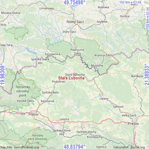
Stará Ľubovňa GPS coordinates[2]
49° 17' 54.924" North, 20° 41' 10.32" East
| Map corner | latitude | longitude |
|---|---|---|
| Upper-left | 49.75498°, | 19.98308° |
| Center: | 49.29859°, | 20.6862° |
| Lower-right: | 48.83794°, | 21.38933° |
| Map W x H: | 102×102 km | = 63.4×63.4mi |
| max Lat: | 49.43503° ⇑6.5% North |
| Stará Ľubovňa: | 49.29859° |
| min Lat: | ⇓93.5% South 47.76356° |
| min Long | Stará Ľubovň | max Long |
| 16.9786° | 20.6862° | 22.18136° |
| W 83.5%⇐ | ⇒16.5% E |
Elevation
Elevation of Stará Ľubovňa is 548 m = 1798 ft, and this is 211.9 m = 695 ft above average elevation for this country.
| Max E: |
1006 m = 3301 ft | 18.2% |
| Stará Ľubovňa | 548 m 1798 ft | |
| Avg. | 336.1 m = 1103 ft | |
Min E: |
102 m = 335 ft | 81.8% |
See also: Slovakia elevation on elevation.city.
Geographical zone
Stará Ľubovňa is located in North temperate zone (between Tropic of Cancer and the Arctic Circle). Distance of this North polar circle is 1919.7 km =1192.8 mi to North.| Distance of | km | miles | from Stará Ľubovňa |
|---|---|---|---|
| North Pole | 4525.6 | 2812.1 | to North |
| Arctic Circle | 1919.7 | 1192.8 | to North |
| Tropic Cancer | 2875.6 | 1786.8 | to South |
| Equator | 5481.5 | 3406 | to South |


Nearby cities:
15 places around Stará Ľubovňa: (largest is in red/bold)
• Bijacovce
31.6 km =19.6 mi,  164°
164°
• Kežmarok
25.8 km =16 mi,  225°
225°
• Levoča
31.5 km =19.6 mi,  192°
192°
• Lipany
25.8 km =16 mi,  128°
128°
• Nová Lesná
36.2 km =22.5 mi,  237°
237°
• Podolínec
11.8 km =7.3 mi,  247°
247°
• Spišská Belá
20.6 km =12.8 mi, 233°
• Spišské Podhradie
33.5 km =20.8 mi,  171°
171°
• Tatranská Lomnica
32.9 km =20.4 mi, 243°
• Vrbov
30.2 km =18.8 mi,  218°
218°
• Vysoké Tatry
36.8 km =22.9 mi, 240°
• Vyšné Ružbachy
8.8 km =5.5 mi,  273°
273°
• Ľubica
26.5 km =16.5 mi, 220°
• Ždiar
30.9 km =19.2 mi,  264°
264°
• Žehra
36.3 km =22.6 mi, 167°
Sources, notices
• [Note1] Compared only with cities in Slovakia existing in our database
• [Src1] Map data: © OpenStreetMap contributors (CC-BY-SA)
• [Src2] Other city data from geonames.org with taken over terms of usage.
• [Src3] Geographical zone / Annual Mean Temperature by Robert A. Rohde @ Wikipedia
