Kavečany geodata
Kavečany (Košický kraj) is a populated place; located in Slovakia in Europe/Bratislava (GMT+2) time zone. With population of 1,287 people, there are 150 cities with bigger population in this country. Compared to other cities in Slovakia, 51.8% of cities are located further ↓South; 89.4% of cities are located further ←West and 71.8% of cities have lower elevation than Kavečany. Note1


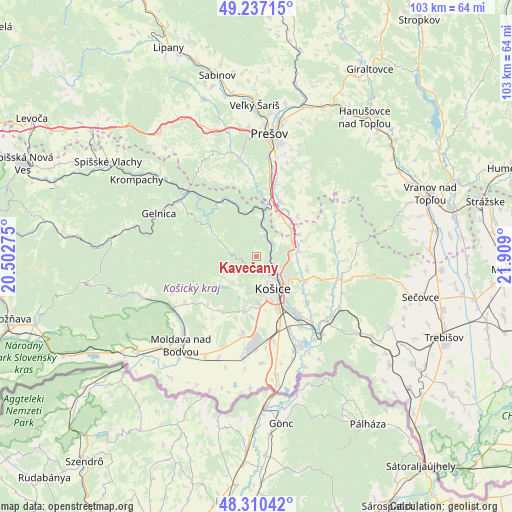
Kavečany GPS coordinates[2]
48° 46' 33.312" North, 21° 12' 21.132" East
| Map corner | latitude | longitude |
|---|---|---|
| Upper-left | 49.23715°, | 20.50275° |
| Center: | 48.77592°, | 21.20587° |
| Lower-right: | 48.31042°, | 21.909° |
| Map W x H: | 103×103 km | = 64×64mi |
| max Lat: | 49.43503° ⇑48.2% North |
| Kavečany: | 48.77592° |
| min Lat: | ⇓51.8% South 47.76356° |
| min Long | Kavečany | max Long |
| 16.9786° | 21.20587° | 22.18136° |
| W 89.4%⇐ | ⇒10.6% E |
Elevation
Elevation of Kavečany is 454 m = 1490 ft, and this is 117.9 m = 387 ft above average elevation for this country.
| Max E: |
1006 m = 3301 ft | 28.2% |
| Kavečany | 454 m 1490 ft | |
| Avg. | 336.1 m = 1103 ft | |
Min E: |
102 m = 335 ft | 71.8% |
See also: Slovakia elevation on elevation.city.
Geographical zone
Kavečany is located in North temperate zone (between Tropic of Cancer and the Arctic Circle). Distance of this North polar circle is 1977.8 km =1228.9 mi to North.| Distance of | km | miles | from Kavečany |
|---|---|---|---|
| North Pole | 4583.7 | 2848.2 | to North |
| Arctic Circle | 1977.8 | 1228.9 | to North |
| Tropic Cancer | 2817.5 | 1750.7 | to South |
| Equator | 5423.4 | 3369.9 | to South |


Nearby cities:
15 places around Kavečany: (largest is in red/bold)
• Bijacovce
40.5 km =25.2 mi,  312°
312°
• Gelnica
21.6 km =13.4 mi,  294°
294°
• Giraltovce
43.9 km =27.3 mi,  31°
31°
• Košice
7.9 km =4.9 mi,  150°
150°
• Krompachy
28.7 km =17.8 mi,  302°
302°
• Lipany
45.6 km =28.3 mi,  337°
337°
• Medzev
24.4 km =15.2 mi,  249°
249°
• Moldava nad Bodvou
23.5 km =14.6 mi,  220°
220°
• Prešov
24.8 km =15.4 mi,  4°
4°
• Sabinov
37.2 km =23.1 mi,  347°
347°
• Sečovce
34.4 km =21.4 mi,  104°
104°
• Spišské Podhradie
41.5 km =25.8 mi, 307°
• Trebišov
41.1 km =25.5 mi,  113°
113°
• Vranov nad Topľou
37.2 km =23.1 mi,  70°
70°
• Žehra
37.8 km =23.5 mi, 306°
Sources, notices
• [Note1] Compared only with cities in Slovakia existing in our database
• [Src1] Map data: © OpenStreetMap contributors (CC-BY-SA)
• [Src2] Other city data from geonames.org with taken over terms of usage.
• [Src3] Geographical zone / Annual Mean Temperature by Robert A. Rohde @ Wikipedia
