Port Loko geodata
Port Loko (North West) is a seat of a first-order administrative division; located in Sierra Leone in Africa/Freetown (GMT+0) time zone. With population of 21,308 people, there are 6 cities with bigger population in this country. Compared to other cities in Sierra Leone, 79.5% of cities are located further ↓South; 83.1% of cities are located further →East and 71.1% of cities have higher elevation than Port Loko. Note1


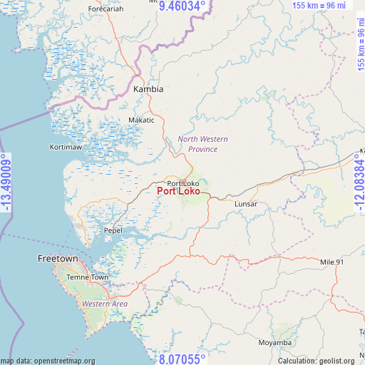
Port Loko GPS coordinates[2]
8° 45' 57.924" North, 12° 47' 13.056" West
| Map corner | latitude | longitude |
|---|---|---|
| Upper-left | 9.46034°, | -13.49009° |
| Center: | 8.76609°, | -12.78696° |
| Lower-right: | 8.07055°, | -12.08384° |
| Map W x H: | 154.5×154.5 km | = 96×96mi |
| max Lat: | 9.91376° ⇑20.5% North |
| Port Loko: | 8.76609° |
| min Lat: | ⇓79.5% South 7.24611° |
| min Long | Port Loko | max Long |
| -13.28972° | -12.78696° | -10.37135° |
| W 16.9%⇐ | ⇒83.1% E |
Elevation
Elevation of Port Loko is 51 m = 167 ft, and this is 106.2 m = 348 ft below average elevation for this country.
| Max E: |
564 m = 1850 ft | 71.1% |
| Avg. | 157.2 m = 516 ft | |
| Port Loko | 51 m = 167 ft | |
Min E: |
1 m = 3 ft | 28.9% |
See also: Sierra Leone elevation on elevation.city.
Geographical zone
Port Loko is located in North Torrid zone (between Equator and Tropic of Cancer). Distance of Equator is 974.7 km =605.7 mi to South.| Distance of | km | miles | from Port Loko |
|---|---|---|---|
| North Pole | 9032.4 | 5612.5 | to North |
| Arctic Circle | 6426.5 | 3993.2 | to North |
| Tropic Cancer | 1631.2 | 1013.6 | to North |
| Equator | 974.7 | 605.7 | to South |


Nearby cities:
15 places around Port Loko: (largest is in red/bold)
• Freetown
58.3 km =36.2 mi,  237°
237°
• Hastings
57.7 km =35.9 mi,  221°
221°
• Kambia
42.4 km =26.3 mi,  340°
340°
• Kassiri
40.8 km =25.4 mi,  297°
297°
• Kent
57.1 km =35.5 mi,  212°
212°
• Konakridee
50.3 km =31.3 mi,  261°
261°
• Lunsar
29.1 km =18.1 mi,  108°
108°
• Mambolo
32.3 km =20.1 mi, 301°
• Mange
19 km =11.8 mi, 336°
• Masoyila
47.6 km =29.6 mi,  248°
248°
• Pepel
35.6 km =22.1 mi, 235°
• Rokupr
45.4 km =28.2 mi,  103°
103°
• Sawkta
48 km =29.8 mi, 251°
• Tintafor
49.5 km =30.8 mi, 251°
• Waterloo
56.8 km =35.3 mi, 213°
Sources, notices
• [Note1] Compared only with cities in Sierra Leone existing in our database
• [Src1] Map data: © OpenStreetMap contributors (CC-BY-SA)
• [Src2] Other city data from geonames.org with taken over terms of usage.
• [Src3] Geographical zone / Annual Mean Temperature by Robert A. Rohde @ Wikipedia
