Pepel geodata
Pepel (Northern Province) is a populated place; located in Sierra Leone in Africa/Freetown (GMT+0) time zone. With population of 4,462 people, there are 50 cities with bigger population in this country. Compared to other cities in Sierra Leone, 60.2% of cities are located further ↓South; 88% of cities are located further →East and 91.6% of cities have higher elevation than Pepel. Note1


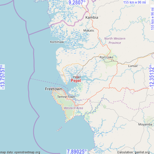
Pepel GPS coordinates[2]
8° 35' 9.996" North, 13° 3' 15.984" West
| Map corner | latitude | longitude |
|---|---|---|
| Upper-left | 9.2807°, | -13.75757° |
| Center: | 8.58611°, | -13.05444° |
| Lower-right: | 7.89025°, | -12.35132° |
| Map W x H: | 154.6×154.6 km | = 96.1×96.1mi |
| max Lat: | 9.91376° ⇑39.8% North |
| Pepel: | 8.58611° |
| min Lat: | ⇓60.2% South 7.24611° |
| min Long | Pepel | max Long |
| -13.28972° | -13.05444° | -10.37135° |
| W 12%⇐ | ⇒88% E |
Elevation
Elevation of Pepel is 20 m = 66 ft, and this is 137.2 m = 450 ft below average elevation for this country.
| Max E: |
564 m = 1850 ft | 91.6% |
| Avg. | 157.2 m = 516 ft | |
| Pepel | 20 m = 66 ft | |
Min E: |
1 m = 3 ft | 8.4% |
See also: Sierra Leone elevation on elevation.city.
Geographical zone
Pepel is located in North Torrid zone (between Equator and Tropic of Cancer). Distance of Equator is 954.7 km =593.2 mi to South.| Distance of | km | miles | from Pepel |
|---|---|---|---|
| North Pole | 9052.4 | 5624.9 | to North |
| Arctic Circle | 6446.5 | 4005.7 | to North |
| Tropic Cancer | 1651.2 | 1026 | to North |
| Equator | 954.7 | 593.2 | to South |


Nearby cities:
15 places around Pepel: (largest is in red/bold)
• Freetown
22.8 km =14.2 mi,  241°
241°
• Freetown
31 km =19.3 mi, 236°
• Hastings
24.7 km =15.3 mi,  201°
201°
• Kassiri
39.7 km =24.7 mi,  350°
350°
• Kent
28.1 km =17.5 mi,  182°
182°
• Konakridee
23.8 km =14.8 mi,  301°
301°
• Lunsar
58.1 km =36.1 mi,  79°
79°
• Mambolo
37 km =23 mi,  3°
3°
• Mange
43.3 km =26.9 mi,  30°
30°
• Masoyila
15.3 km =9.5 mi,  280°
280°
• Port Loko
35.6 km =22.1 mi,  55°
55°
• Rotifunk
57.6 km =35.8 mi,  134°
134°
• Sawkta
17.1 km =10.6 mi,  287°
287°
• Tintafor
18.2 km =11.3 mi, 284°
• Waterloo
27.5 km =17.1 mi, 183°
Sources, notices
• [Note1] Compared only with cities in Sierra Leone existing in our database
• [Src1] Map data: © OpenStreetMap contributors (CC-BY-SA)
• [Src2] Other city data from geonames.org with taken over terms of usage.
• [Src3] Geographical zone / Annual Mean Temperature by Robert A. Rohde @ Wikipedia
