Kambia geodata
Kambia (Northern Province) is a populated place; located in Sierra Leone in Africa/Freetown (GMT+0) time zone. With population of 11,520 people, there are 17 cities with bigger population in this country. Compared to other cities in Sierra Leone, 91.6% of cities are located further ↓South; 85.5% of cities are located further →East and 84.3% of cities have higher elevation than Kambia. Note1


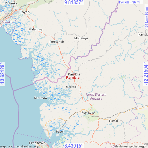
Kambia GPS coordinates[2]
9° 7' 30.144" North, 12° 55' 5.376" West
| Map corner | latitude | longitude |
|---|---|---|
| Upper-left | 9.81857°, | -13.62129° |
| Center: | 9.12504°, | -12.91816° |
| Lower-right: | 8.43015°, | -12.21504° |
| Map W x H: | 154.4×154.4 km | = 95.9×95.9mi |
| max Lat: | 9.91376° ⇑8.4% North |
| Kambia: | 9.12504° |
| min Lat: | ⇓91.6% South 7.24611° |
| min Long | Kambia | max Long |
| -13.28972° | -12.91816° | -10.37135° |
| W 14.5%⇐ | ⇒85.5% E |
Elevation
Elevation of Kambia is 32 m = 105 ft, and this is 125.2 m = 411 ft below average elevation for this country.
| Max E: |
564 m = 1850 ft | 84.3% |
| Avg. | 157.2 m = 516 ft | |
| Kambia | 32 m = 105 ft | |
Min E: |
1 m = 3 ft | 15.7% |
See also: Sierra Leone elevation on elevation.city.
Geographical zone
Kambia is located in North Torrid zone (between Equator and Tropic of Cancer). Distance of Equator is 1014.6 km =630.4 mi to South.| Distance of | km | miles | from Kambia |
|---|---|---|---|
| North Pole | 8992.5 | 5587.7 | to North |
| Arctic Circle | 6386.6 | 3968.4 | to North |
| Tropic Cancer | 1591.3 | 988.8 | to North |
| Equator | 1014.6 | 630.4 | to South |


Nearby cities:
15 places around Kambia: (largest is in red/bold)
• Freetown
79 km =49.1 mi,  206°
206°
• Hastings
86.3 km =53.6 mi,  196°
196°
• Kamakwie
85.1 km =52.9 mi,  60°
60°
• Kassiri
30 km =18.6 mi,  226°
226°
• Konakridee
59.2 km =36.8 mi,  216°
216°
• Kukuna
41.2 km =25.6 mi,  42°
42°
• Lunsar
64.6 km =40.1 mi,  139°
139°
• Mambolo
26.4 km =16.4 mi, 209°
• Mange
23.5 km =14.6 mi,  163°
163°
• Masoyila
64.5 km =40.1 mi, 207°
• Pepel
61.8 km =38.4 mi,  194°
194°
• Port Loko
42.4 km =26.3 mi, 160°
• Rokupr
77.3 km =48 mi,  130°
130°
• Sawkta
63.1 km =39.2 mi, 209°
• Tintafor
64.3 km =40 mi, 210°
Sources, notices
• [Note1] Compared only with cities in Sierra Leone existing in our database
• [Src1] Map data: © OpenStreetMap contributors (CC-BY-SA)
• [Src2] Other city data from geonames.org with taken over terms of usage.
• [Src3] Geographical zone / Annual Mean Temperature by Robert A. Rohde @ Wikipedia
