Hastings geodata
Hastings (Western Area) is a populated place; located in Sierra Leone in Africa/Freetown (GMT+0) time zone. With population of 5,121 people, there are 44 cities with bigger population in this country. Compared to other cities in Sierra Leone, 53% of cities are located further ↓South; 92.8% of cities are located further →East and 72.3% of cities have higher elevation than Hastings. Note1


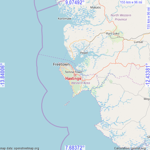
Hastings GPS coordinates[2]
8° 22' 47.784" North, 13° 8' 12.948" West
| Map corner | latitude | longitude |
|---|---|---|
| Upper-left | 9.07492°, | -13.84006° |
| Center: | 8.37994°, | -13.13693° |
| Lower-right: | 7.68372°, | -12.43381° |
| Map W x H: | 154.7×154.7 km | = 96.1×96.1mi |
| max Lat: | 9.91376° ⇑47% North |
| Hastings: | 8.37994° |
| min Lat: | ⇓53% South 7.24611° |
| min Long | Hastings | max Long |
| -13.28972° | -13.13693° | -10.37135° |
| W 7.2%⇐ | ⇒92.8% E |
Elevation
Elevation of Hastings is 50 m = 164 ft, and this is 107.2 m = 352 ft below average elevation for this country.
| Max E: |
564 m = 1850 ft | 72.3% |
| Avg. | 157.2 m = 516 ft | |
| Hastings | 50 m = 164 ft | |
Min E: |
1 m = 3 ft | 27.7% |
See also: Sierra Leone elevation on elevation.city.
Geographical zone
Hastings is located in North Torrid zone (between Equator and Tropic of Cancer). Distance of Equator is 931.8 km =579 mi to South.| Distance of | km | miles | from Hastings |
|---|---|---|---|
| North Pole | 9075.3 | 5639.1 | to North |
| Arctic Circle | 6469.4 | 4019.9 | to North |
| Tropic Cancer | 1674.2 | 1040.3 | to North |
| Equator | 931.8 | 579 | to South |


Nearby cities:
15 places around Hastings: (largest is in red/bold)
• Freetown
16.1 km =10 mi,  317°
317°
• Freetown
17.8 km =11.1 mi,  288°
288°
• Kassiri
62.1 km =38.6 mi,  2°
2°
• Kent
9.3 km =5.8 mi,  123°
123°
• Konakridee
37.1 km =23.1 mi,  342°
342°
• Lunsar
74.3 km =46.2 mi,  62°
62°
• Mambolo
60.9 km =37.8 mi,  10°
10°
• Mange
67.7 km =42.1 mi,  27°
27°
• Masoyila
26.4 km =16.4 mi,  346°
346°
• Pepel
24.7 km =15.3 mi,  21°
21°
• Port Loko
57.7 km =35.9 mi,  41°
41°
• Rotifunk
53.4 km =33.2 mi,  108°
108°
• Sawkta
29 km =18 mi, 345°
• Tintafor
28.7 km =17.8 mi, 342°
• Waterloo
8.6 km =5.3 mi, 122°
Sources, notices
• [Note1] Compared only with cities in Sierra Leone existing in our database
• [Src1] Map data: © OpenStreetMap contributors (CC-BY-SA)
• [Src2] Other city data from geonames.org with taken over terms of usage.
• [Src3] Geographical zone / Annual Mean Temperature by Robert A. Rohde @ Wikipedia
