Mange geodata
Mange (Northern Province) is a populated place; located in Sierra Leone in Africa/Freetown (GMT+0) time zone. With population of 3,339 people, there are 69 cities with bigger population in this country. Compared to other cities in Sierra Leone, 85.5% of cities are located further ↓South; 84.3% of cities are located further →East and 92.8% of cities have higher elevation than Mange. Note1


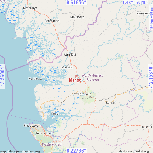
Mange GPS coordinates[2]
8° 55' 21.432" North, 12° 51' 24.768" West
| Map corner | latitude | longitude |
|---|---|---|
| Upper-left | 9.61656°, | -13.56001° |
| Center: | 8.92262°, | -12.85688° |
| Lower-right: | 8.22736°, | -12.15376° |
| Map W x H: | 154.5×154.5 km | = 96×96mi |
| max Lat: | 9.91376° ⇑14.5% North |
| Mange: | 8.92262° |
| min Lat: | ⇓85.5% South 7.24611° |
| min Long | Mange | max Long |
| -13.28972° | -12.85688° | -10.37135° |
| W 15.7%⇐ | ⇒84.3% E |
Elevation
Elevation of Mange is 19 m = 62 ft, and this is 138.2 m = 453 ft below average elevation for this country.
| Max E: |
564 m = 1850 ft | 92.8% |
| Avg. | 157.2 m = 516 ft | |
| Mange | 19 m = 62 ft | |
Min E: |
1 m = 3 ft | 7.2% |
See also: Sierra Leone elevation on elevation.city.
Geographical zone
Mange is located in North Torrid zone (between Equator and Tropic of Cancer). Distance of Equator is 992.1 km =616.5 mi to South.| Distance of | km | miles | from Mange |
|---|---|---|---|
| North Pole | 9015 | 5601.7 | to North |
| Arctic Circle | 6409.1 | 3982.4 | to North |
| Tropic Cancer | 1613.8 | 1002.8 | to North |
| Equator | 992.1 | 616.5 | to South |


Nearby cities:
15 places around Mange: (largest is in red/bold)
• Freetown
63.9 km =39.7 mi,  220°
220°
• Hastings
67.7 km =42.1 mi,  207°
207°
• Kambia
23.5 km =14.6 mi,  343°
343°
• Kassiri
28.4 km =17.6 mi,  273°
273°
• Konakridee
48.9 km =30.4 mi,  239°
239°
• Kukuna
57 km =35.4 mi,  21°
21°
• Lunsar
44.2 km =27.5 mi,  126°
126°
• Mambolo
19.8 km =12.3 mi, 268°
• Masoyila
50.5 km =31.4 mi,  226°
226°
• Pepel
43.3 km =26.9 mi, 210°
• Port Loko
19 km =11.8 mi,  156°
156°
• Rokupr
58.9 km =36.6 mi,  118°
118°
• Sawkta
49.8 km =30.9 mi, 229°
• Tintafor
51.3 km =31.9 mi, 230°
• Waterloo
69 km =42.9 mi,  199°
199°
Sources, notices
• [Note1] Compared only with cities in Sierra Leone existing in our database
• [Src1] Map data: © OpenStreetMap contributors (CC-BY-SA)
• [Src2] Other city data from geonames.org with taken over terms of usage.
• [Src3] Geographical zone / Annual Mean Temperature by Robert A. Rohde @ Wikipedia
