Freetown geodata
Freetown (Western Area) is a populated place; located in Sierra Leone in Africa/Freetown (GMT+0) time zone. With population of 13,768 people, there are 13 cities with bigger population in this country. Compared to other cities in Sierra Leone, 54.2% of cities are located further ↓South; 100% of cities are located further →East and 96.4% of cities have higher elevation than Freetown. Note1


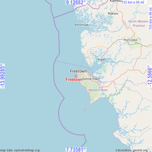
Freetown GPS coordinates[2]
8° 25' 54.984" North, 13° 17' 22.992" West
| Map corner | latitude | longitude |
|---|---|---|
| Upper-left | 9.12682°, | -13.99285° |
| Center: | 8.43194°, | -13.28972° |
| Lower-right: | 7.73581°, | -12.5866° |
| Map W x H: | 154.7×154.7 km | = 96.1×96.1mi |
| max Lat: | 9.91376° ⇑45.8% North |
| Freetown: | 8.43194° |
| min Lat: | ⇓54.2% South 7.24611° |
| min Long | Freetown | max Long |
| -13.28972° | -13.28972° | -10.37135° |
| W 0%⇐ | ⇒100% E |
Elevation
Elevation of Freetown is 15 m = 49 ft, and this is 142.2 m = 467 ft below average elevation for this country.
| Max E: |
564 m = 1850 ft | 96.4% |
| Avg. | 157.2 m = 516 ft | |
| Freetown | 15 m = 49 ft | |
Min E: |
1 m = 3 ft | 3.6% |
See also: Sierra Leone elevation on elevation.city.
Geographical zone
Freetown is located in North Torrid zone (between Equator and Tropic of Cancer). Distance of Equator is 937.5 km =582.5 mi to South.| Distance of | km | miles | from Freetown |
|---|---|---|---|
| North Pole | 9069.5 | 5635.5 | to North |
| Arctic Circle | 6463.6 | 4016.3 | to North |
| Tropic Cancer | 1668.4 | 1036.7 | to North |
| Equator | 937.5 | 582.5 | to South |


Nearby cities:
15 places around Freetown: (largest is in red/bold)
• Freetown
8.5 km =5.3 mi,  44°
44°
• Hastings
17.8 km =11.1 mi,  108°
108°
• Kambia
87.2 km =54.2 mi,  27°
27°
• Kassiri
59.5 km =37 mi,  18°
18°
• Kent
26.9 km =16.7 mi, 114°
• Konakridee
30.1 km =18.7 mi,  10°
10°
• Mambolo
60.8 km =37.8 mi, 27°
• Mange
72.4 km =45 mi, 41°
• Masoyila
22.7 km =14.1 mi, 28°
• Pepel
31 km =19.3 mi,  56°
56°
• Port Loko
66.6 km =41.4 mi, 56°
• Rotifunk
71.1 km =44.2 mi, 108°
• Sawkta
24.3 km =15.1 mi, 23°
• Tintafor
23.2 km =14.4 mi, 20°
• Waterloo
26.2 km =16.3 mi, 113°
Sources, notices
• [Note1] Compared only with cities in Sierra Leone existing in our database
• [Src1] Map data: © OpenStreetMap contributors (CC-BY-SA)
• [Src2] Other city data from geonames.org with taken over terms of usage.
• [Src3] Geographical zone / Annual Mean Temperature by Robert A. Rohde @ Wikipedia
