Ndofane geodata
Ndofane (Kaolack) is a populated place; located in Senegal in Africa/Dakar (GMT+0) time zone. With population of 9,946 people, there are 40 cities with bigger population in this country. Compared to other cities in Senegal, 78.3% of cities are located further ↑North; 60% of cities are located further ←West and 61.7% of cities have lower elevation than Ndofane. Note1


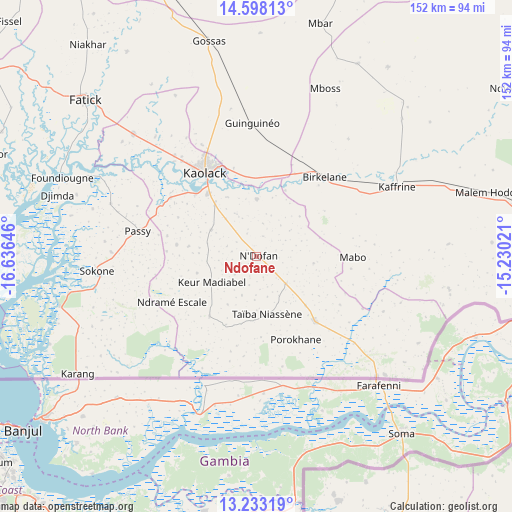
Ndofane GPS coordinates[2]
13° 55' 0.012" North, 15° 55' 59.988" West
| Map corner | latitude | longitude |
|---|---|---|
| Upper-left | 14.59813°, | -16.63646° |
| Center: | 13.91667°, | -15.93333° |
| Lower-right: | 13.23319°, | -15.23021° |
| Map W x H: | 151.8×151.8 km | = 94.3×94.3mi |
| max Lat: | 16.51293° ⇑78.3% North |
| Ndofane: | 13.91667° |
| min Lat: | ⇓21.7% South 12.485° |
| min Long | Ndofane | max Long |
| -17.47581° | -15.93333° | -12.18076° |
| W 60%⇐ | ⇒40% E |
Elevation
Elevation of Ndofane is 22 m = 72 ft, and this is 2.5 m = 8 ft below average elevation for this country.
| Max E: |
127 m = 417 ft | 38.3% |
| Avg. | 24.5 m = 80 ft | |
| Ndofane | 22 m = 72 ft | |
Min E: |
0 m = 0 ft | 61.7% |
See also: Senegal elevation on elevation.city.
Geographical zone
Ndofane is located in North Torrid zone (between Equator and Tropic of Cancer). Distance of this Northern Tropic circle is 1058.5 km =657.7 mi to North.| Distance of | km | miles | from Ndofane |
|---|---|---|---|
| North Pole | 8459.7 | 5256.6 | to North |
| Arctic Circle | 5853.8 | 3637.4 | to North |
| Tropic Cancer | 1058.5 | 657.7 | to North |
| Equator | 1547.4 | 961.5 | to South |


Nearby cities:
15 places around Ndofane: (largest is in red/bold)
• Baboucar Toumbou
87.4 km =54.3 mi,  284°
284°
• Diofior
84.5 km =52.5 mi,  290°
290°
• Diourbel
87.9 km =54.6 mi,  337°
337°
• Fatick
68.7 km =42.7 mi,  312°
312°
• Foundiougne
62.4 km =38.8 mi, 292°
• Gandiaye
50.3 km =31.3 mi, 314°
• Guinguinéo
39 km =24.2 mi,  357°
357°
• Kaffrine
46.3 km =28.8 mi,  62°
62°
• Kaolack
30.2 km =18.8 mi,  330°
330°
• Keur Babakar Toumbou
87.4 km =54.3 mi, 284°
• Nioro du Rip
23.5 km =14.6 mi,  142°
142°
• Passi
36.7 km =22.8 mi, 281°
• Pourham
71 km =44.1 mi, 312°
• Sokone
46.9 km =29.1 mi,  265°
265°
• Tiébo
86 km =53.4 mi, 337°
Sources, notices
• [Note1] Compared only with cities in Senegal existing in our database
• [Src1] Map data: © OpenStreetMap contributors (CC-BY-SA)
• [Src2] Other city data from geonames.org with taken over terms of usage.
• [Src3] Geographical zone / Annual Mean Temperature by Robert A. Rohde @ Wikipedia
