Kaffrine geodata
Kaffrine is a seat of a first-order administrative division; located in Senegal in Africa/Dakar (GMT+0) time zone. With population of 28,396 people, there are 17 cities with bigger population in this country. Compared to other cities in Senegal, 73.3% of cities are located further ↑North; 71.7% of cities are located further ←West and 68.3% of cities have higher elevation than Kaffrine. Note1


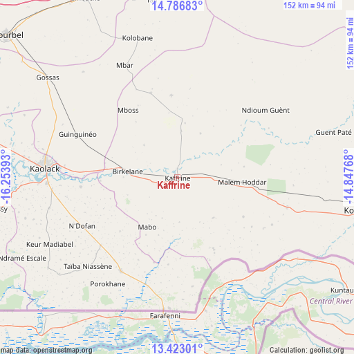
Kaffrine GPS coordinates[2]
14° 6' 21.384" North, 15° 33' 2.88" West
| Map corner | latitude | longitude |
|---|---|---|
| Upper-left | 14.78683°, | -16.25393° |
| Center: | 14.10594°, | -15.5508° |
| Lower-right: | 13.42301°, | -14.84768° |
| Map W x H: | 151.6×151.6 km | = 94.2×94.2mi |
| max Lat: | 16.51293° ⇑73.3% North |
| Kaffrine: | 14.10594° |
| min Lat: | ⇓26.7% South 12.485° |
| min Long | Kaffrine | max Long |
| -17.47581° | -15.5508° | -12.18076° |
| W 71.7%⇐ | ⇒28.3% E |
Elevation
Elevation of Kaffrine is 15 m = 49 ft, and this is 9.5 m = 31 ft below average elevation for this country.
| Max E: |
127 m = 417 ft | 68.3% |
| Avg. | 24.5 m = 80 ft | |
| Kaffrine | 15 m = 49 ft | |
Min E: |
0 m = 0 ft | 31.7% |
See also: Senegal elevation on elevation.city.
Geographical zone
Kaffrine is located in North Torrid zone (between Equator and Tropic of Cancer). Distance of this Northern Tropic circle is 1037.5 km =644.7 mi to North.| Distance of | km | miles | from Kaffrine |
|---|---|---|---|
| North Pole | 8438.6 | 5243.5 | to North |
| Arctic Circle | 5832.7 | 3624.3 | to North |
| Tropic Cancer | 1037.5 | 644.7 | to North |
| Equator | 1568.4 | 974.6 | to South |


Nearby cities:
15 places around Kaffrine: (largest is in red/bold)
• Diourbel
95.9 km =59.6 mi,  308°
308°
• Fatick
95.5 km =59.3 mi,  285°
285°
• Foundiougne
98.8 km =61.4 mi,  271°
271°
• Gandiaye
78.5 km =48.8 mi,  280°
280°
• Guinguinéo
46.6 km =29 mi, 292°
• Kaolack
56.5 km =35.1 mi, 275°
• Koungheul
82.1 km =51 mi,  99°
99°
• Mbaké
85.3 km =53 mi,  333°
333°
• Ndofane
46.3 km =28.8 mi,  242°
242°
• Nioro du Rip
47.8 km =29.7 mi,  214°
214°
• Passi
78.4 km =48.7 mi,  259°
259°
• Pourham
97.2 km =60.4 mi, 286°
• Sokone
91.4 km =56.8 mi,  254°
254°
• Tiébo
94 km =58.4 mi, 308°
• Touba
90.1 km =56 mi,  336°
336°
Sources, notices
• [Note1] Compared only with cities in Senegal existing in our database
• [Src1] Map data: © OpenStreetMap contributors (CC-BY-SA)
• [Src2] Other city data from geonames.org with taken over terms of usage.
• [Src3] Geographical zone / Annual Mean Temperature by Robert A. Rohde @ Wikipedia
