Renk geodata
Renk (Northern Upper Nile) is a seat of a first-order administrative division; located in South Sudan in Africa/Juba (GMT+2) time zone. In our database, there are 19 cities with bigger population. Compared to other cities in South Sudan, 100% of cities are located further ↓South; 84.8% of cities are located further ←West and 100% of cities have higher elevation than Renk. Note1


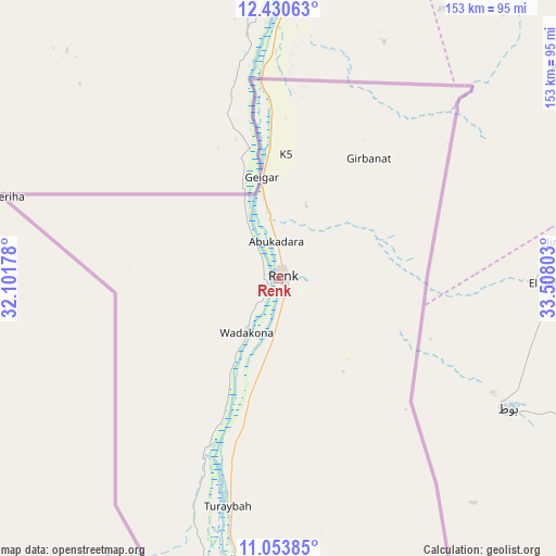
Renk GPS coordinates[2]
11° 44' 35.16" North, 32° 48' 17.64" East
| Map corner | latitude | longitude |
|---|---|---|
| Upper-left | 12.43063°, | 32.10178° |
| Center: | 11.7431°, | 32.8049° |
| Lower-right: | 11.05385°, | 33.50803° |
| Map W x H: | 153.1×153.1 km | = 95.1×95.1mi |
| max Lat: | 11.7431° ⇑0% North |
| Renk: | 11.7431° |
| min Lat: | ⇓100% South 3.86512° |
| min Long | Renk | max Long |
| 25.67833° | 32.8049° | 33.92621° |
| W 84.8%⇐ | ⇒15.2% E |
Elevation
Elevation of Renk is 392 m = 1286 ft, and this is 96.9 m = 318 ft below average elevation for this country.
| Max E: |
836 m = 2743 ft | 100% |
| Avg. | 488.9 m = 1604 ft | |
| Renk | 392 m = 1286 ft | |
Min E: |
392 m = 1286 ft | 0% |
See also: South Sudan elevation on elevation.city.
Geographical zone
Renk is located in North Torrid zone (between Equator and Tropic of Cancer). Distance of this Northern Tropic circle is 1300.2 km =807.9 mi to North.| Distance of | km | miles | from Renk |
|---|---|---|---|
| North Pole | 8701.4 | 5406.8 | to North |
| Arctic Circle | 6095.5 | 3787.6 | to North |
| Tropic Cancer | 1300.2 | 807.9 | to North |
| Equator | 1305.7 | 811.3 | to South |


Nearby cities:
9 places around Renk: (largest is in red/bold)
• Akobo
440 km =273.4 mi,  177°
177°
• Ayod
430.7 km =267.6 mi,  200°
200°
• Bentiu
429.4 km =266.8 mi,  229°
229°
• Kodok
219.7 km =136.5 mi, 200°
• Maiwut
369.4 km =229.5 mi,  160°
160°
• Malakal
275.7 km =171.3 mi,  206°
206°
• Nasir
348.8 km =216.7 mi, 175°
• Pariang
369.3 km =229.5 mi,  236°
236°
• Waat
402.7 km =250.2 mi,  190°
190°
Sources, notices
• [Note1] Compared only with cities in South Sudan existing in our database
• [Src1] Map data: © OpenStreetMap contributors (CC-BY-SA)
• [Src2] Other city data from geonames.org with taken over terms of usage.
• [Src3] Geographical zone / Annual Mean Temperature by Robert A. Rohde @ Wikipedia
