Ayod geodata
Ayod (Fangak) is a seat of a first-order administrative division; located in South Sudan in Africa/Juba (GMT+2) time zone. In our database, there are 19 cities with bigger population. Compared to other cities in South Sudan, 54.5% of cities are located further ↓South; 57.6% of cities are located further ←West and 75.8% of cities have higher elevation than Ayod. Note1


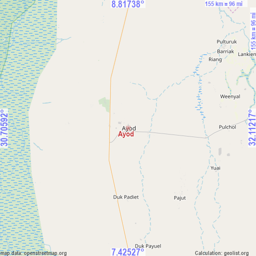
Ayod GPS coordinates[2]
8° 7' 18.948" North, 31° 24' 32.544" East
| Map corner | latitude | longitude |
|---|---|---|
| Upper-left | 8.81738°, | 30.70592° |
| Center: | 8.12193°, | 31.40904° |
| Lower-right: | 7.42527°, | 32.11217° |
| Map W x H: | 154.8×154.8 km | = 96.2×96.2mi |
| max Lat: | 11.7431° ⇑45.5% North |
| Ayod: | 8.12193° |
| min Lat: | ⇓54.5% South 3.86512° |
| min Long | Ayod | max Long |
| 25.67833° | 31.40904° | 33.92621° |
| W 57.6%⇐ | ⇒42.4% E |
Elevation
Elevation of Ayod is 411 m = 1348 ft, and this is 77.9 m = 256 ft below average elevation for this country.
| Max E: |
836 m = 2743 ft | 75.8% |
| Avg. | 488.9 m = 1604 ft | |
| Ayod | 411 m = 1348 ft | |
Min E: |
392 m = 1286 ft | 24.2% |
See also: South Sudan elevation on elevation.city.
Geographical zone
Ayod is located in North Torrid zone (between Equator and Tropic of Cancer). Distance of Equator is 903.1 km =561.2 mi to South.| Distance of | km | miles | from Ayod |
|---|---|---|---|
| North Pole | 9104 | 5657 | to North |
| Arctic Circle | 6498.1 | 4037.7 | to North |
| Tropic Cancer | 1702.8 | 1058.1 | to North |
| Equator | 903.1 | 561.2 | to South |


Nearby cities:
15 places around Ayod: (largest is in red/bold)
• Akobo
179.5 km =111.5 mi,  101°
101°
• Bentiu
217.4 km =135.1 mi,  305°
305°
• Bor
213.3 km =132.5 mi,  175°
175°
• Cueibet
267.7 km =166.3 mi,  242°
242°
• Kodok
211 km =131.1 mi,  21°
21°
• Leer
141 km =87.6 mi,  278°
278°
• Maiwut
282.2 km =175.4 mi,  78°
78°
• Malakal
159.4 km =99 mi,  9°
9°
• Nasir
190 km =118.1 mi,  73°
73°
• Pariang
253.7 km =157.6 mi,  321°
321°
• Pibor
240.1 km =149.2 mi,  127°
127°
• Rumbek
240.5 km =149.4 mi,  232°
232°
• Terekeka
300.2 km =186.5 mi,  172°
172°
• Waat
82 km =51 mi,  85°
85°
• Yirol
201.4 km =125.1 mi,  209°
209°
Sources, notices
• [Note1] Compared only with cities in South Sudan existing in our database
• [Src1] Map data: © OpenStreetMap contributors (CC-BY-SA)
• [Src2] Other city data from geonames.org with taken over terms of usage.
• [Src3] Geographical zone / Annual Mean Temperature by Robert A. Rohde @ Wikipedia
